
Maps of the Ancient Sea Kings
Evidence of Advanced Civilization in the Ice Age — The 1966 Book That Made the Piri Reis Map Famous
Core Thesis
Maps of the Ancient Sea Kings is the origin of one of the most durable claims in fringe archaeology, and it is worth reading because the claim's route into global circulation runs straight through it. Charles H. Hapgood argued in 1966 that a set of early modern charts — the Piri Reis map of 1513 above all, together with the Oronteus Finaeus and Hadji Ahmed maps — preserve survey data inherited from an advanced maritime civilisation that existed many thousands of years before ancient Egypt, and that the Piri Reis chart depicts the Antarctic coast free of ice. Two years later Chariots of the Gods? folded the claim into the ancient-astronaut case and gave it an audience of tens of millions. This site's ancient record file on the map is stamped Debunked.
About the Author
Charles H. Hapgood (1904–1982) was an American college instructor who taught history and the history of science, and it matters for assessing this book that his qualifications were in neither cartography nor geology — the two fields his arguments most depend on.
His earlier and better-known contribution was the earth crust displacement hypothesis, which held that the entire lithosphere could shift over the interior, relocating the poles and producing rapid climatic catastrophe. Albert Einstein wrote a foreword to Hapgood's 1958 book on the subject, and that endorsement has been cited ever since as though it settled something.
It did not, and the point should be stated carefully. Einstein's foreword was written before plate tectonics was established and expressed interest in an idea he thought deserved examination; the geological community subsequently developed plate tectonics, which explains continental movement by a different and thoroughly evidenced mechanism, and crustal displacement has no support in modern geophysics.
The cartographic work in this book grew out of that framework. If the poles had shifted catastrophically, an ice-free Antarctica within human history became possible, and maps appearing to show one became evidence. The argument runs in that direction — from the geological hypothesis to the map reading — rather than the reverse.
Hapgood worked with students on the map analysis and the book presents the results as collaborative research. That is genuine and it is also part of the problem: enthusiastic amateur analysis of technical material, conducted without the specialist knowledge of early modern cartographic practice that the material requires.
Historical Context & Origins
The Piri Reis map itself is a real and important document, and its history is well established. A fragment of gazelle-skin parchment found at Topkapı Palace in Istanbul in late 1929, it is a little over a third of a world map completed by the Ottoman admiral and cartographer Piri Reis in 1513 and presented to Sultan Selim I in Cairo four years later.
The circumstances of the rediscovery are worth stating plainly, because later retellings tend to give them an air of mystery they do not have. The fragment surfaced during the cataloguing of the palace collections in the years after the Ottoman collapse, when imperial holdings were being inventoried as museum material. It was identified by scholars working through that archive, published, and studied. It is a documented library find, not a suppressed document or a smuggled one.
It is also worth being precise about what makes the map genuinely remarkable, because the real answer is more interesting than the invented one. Its Atlantic coastlines are good for 1513 — barely two decades after first contact with the Americas — and its inclusion of material attributed to Columbus makes it a witness to a lost source document. Historians of cartography value it for exactly that. The claim that it also records a survey nobody could have made is not an addition to its importance; it is a distraction from it.
Piri Reis said in his own marginal notes how he made it: by compiling roughly twenty older source charts, including — in his words — a map drawn by 'Colombo' covering the western region, a document otherwise lost and known only through this secondhand reference. The map is a compilation, and it says so.
The surviving fragment shows the Iberian coast, west Africa, the Caribbean and the eastern coast of South America in recognisable and in places strikingly good detail, and then trails off at the parchment's lower edge into a southern coastline that swings sharply east. That stray line is the whole basis of the Antarctica claim.
The cartographic reading is different and better supported. Historians who have examined the map's construction, its marginal notes and sixteenth-century mapmaking conventions read the southern coastline as the coast of South America, distorted by the practice of bending a landmass to fit the available parchment — a convention documented in other charts of the period.
The Antarctic coast the claim requires has been under ice for a great deal longer than any human civilisation has existed. The continent's ice sheet is millions of years old on the relevant timescales, and there is no window in which humans could have surveyed the subglacial coastline.
The claim's route to fame runs through von Däniken. Chariots of the Gods? in 1968 took Hapgood's reading, stripped its geological framework, and presented the map as evidence of aerial survey by visitors — which is how most people who have heard of the Piri Reis map encountered it.
The 1996 Adventures Unlimited reissue, which is the edition in print, brought the book back after two decades out of print and into the alternative-history market that Graham Hancock's work had by then substantially enlarged.
Core Arguments & Key Concepts
Some early modern maps show detail their makers should not have had. The book's foundational claim and the one with a legitimate kernel. The Piri Reis chart's rendering of the South American coast is genuinely good for 1513, and asking how is a reasonable question. The answer is in the map's own marginal notes: it is a compilation of about twenty earlier charts.
That detail derives from a lost civilisation's survey. The inference, and it does not follow. Compilation from earlier sources explains unexpected accuracy without requiring anything lost, and Piri Reis himself documented the compilation.
The Piri Reis map's southern coastline is ice-free Antarctica. The book's most famous claim and its weakest. The cartographic reading identifies it as South America bent east to fit the parchment; the Antarctic coast has been under ice for millions of years; and no human survey of it was possible.
Crustal displacement made an ice-free Antarctica possible within human history. The geological premise the whole argument rests on. It has no support in modern geophysics, and plate tectonics — developed after Hapgood wrote — accounts for continental movement by a mechanism with an enormous evidential base.
Systematic analysis of map projections can recover their source data. Hapgood's methodological claim, and the most interesting thing in the book. In principle it is sound: the geometry of a chart does carry information about how it was made. In practice it requires knowledge of period cartographic convention that the analysis lacks.
Einstein's foreword lends the framework authority. The argument's most-cited external support and its most misused. A foreword written before plate tectonics, expressing interest in an idea worth examining, is not an endorsement of a geological mechanism the subsequent science does not support.
The book's real subject is a legitimate question badly answered. Early modern cartography did transmit information across centuries and cultures in ways that are genuinely interesting, and the compilation practice Piri Reis describes is a real historical phenomenon. That is the story here, and Hapgood walked past it.
Key Cases & Evidence Discussed
The Piri Reis map, 1513. The Topkapı fragment, its 1929 rediscovery, its compilation from roughly twenty earlier charts including a lost Columbus map, and the southern coastline at the parchment's edge. This site's ancient record file covers it and stamps it Debunked.
The Oronteus Finaeus map, 1531. The world map by Oronce Finé whose southern continent Hapgood read as an ice-free Antarctica, against the well-documented cartographic convention of a speculative Terra Australis drawn to balance the northern landmasses.
The Hadji Ahmed map, 1559. A further Ottoman chart brought into the argument as corroboration of the same inherited survey data.
The portolan chart tradition. The medieval and early modern navigational charts whose accuracy Hapgood treats as anomalous, and whose development from accumulated pilot experience is documented in the history of cartography.
Earth crust displacement. Hapgood's own geological hypothesis, the framework the whole book depends on, and the reason an ice-free Antarctica within human history was thought possible.
Einstein's foreword. The 1958 endorsement of the crustal-displacement book, written before plate tectonics, and its subsequent career as a credential in alternative-history writing.
The Antarctic ice sheet. The physical fact the claim collides with — a continental ice sheet on timescales of millions of years, with no window for human survey of the coastline beneath it.
The route into ancient-astronaut literature. Von Däniken's 1968 adoption of the Piri Reis claim, which detached it from Hapgood's geology and made it evidence of aerial survey by visitors.
Critical Reception & Controversies
The book was published by a mainstream trade house in 1966 and taken more seriously at the time than it would be now, partly because Hapgood was a college instructor writing in a scholarly register and partly because the Einstein connection gave the underlying framework an unearned respectability.
The decisive criticism came from historians of cartography, and it is specific rather than general. The Piri Reis map's southern coastline reads as South America distorted to fit the parchment; the practice is documented in other charts of the period; and the map's own marginal notes describe the compilation process that accounts for its accuracy. There is nothing left over requiring a lost civilisation.
The geological foundation failed independently and comprehensively. Plate tectonics was established through the 1960s on an enormous evidential base — seafloor spreading, palaeomagnetism, seismicity, direct measurement — and crustal displacement has no place in it. The book's premise was obsolete almost as soon as it was published.
The Einstein foreword deserves particular attention because it is still deployed. It was written in 1953 for a different book, before the tectonic revolution, and it expressed interest in an idea Einstein thought worth investigating. Presenting it as scientific endorsement of a hypothesis the subsequent science rejected is a misuse that has now run for seventy years.
It should be said in Hapgood's favour that he was not a fabricator. He worked from real maps, published his reasoning, showed his projections and invited examination — which is more than most authors in this genre do, and it is why the refutation was possible in the specific terms it took.
The book's afterlife has been almost entirely outside its own argument. Most people who know the Piri Reis claim met it through von Däniken or through later alternative-history writing, without the crustal-displacement framework that made it coherent on Hapgood's own terms.
The fair placement is as the origin document for a claim that has been answered, written by an amateur working honestly on material that required expertise he did not have. Read it to see where the Piri Reis story came from; read the cartographic literature for what the map actually is.
Influence & Legacy
The book put the Piri Reis map into world circulation as a mystery, and that is its lasting effect. The map is a genuinely important document in the history of cartography and almost nobody encounters it that way; they encounter it as evidence of something lost, which is Hapgood's frame carried by von Däniken's distribution.
It also supplied the alternative-history genre with one of its foundational moves: taking a real artefact with a documented provenance, identifying a feature that seems anomalous to a non-specialist, and building a lost civilisation on it. Later writers have used the same structure repeatedly.
The Einstein foreword has had an influence out of all proportion to what it says, and it is now a standing example of how a scientist's expression of interest becomes, through repetition, an endorsement. Anyone assessing a fringe claim that cites a famous scientist's support should go and read what the scientist actually wrote.
There is a further consequence that is easy to miss. Because the book's argument depends on a geological hypothesis most of its later readers have never heard of, the Piri Reis claim now circulates entirely detached from any mechanism at all. Hapgood at least had an answer to the obvious question — how could anyone have seen an ice-free Antarctic coast? — even though the answer was wrong. Stripped of it, the claim survives as a bare anomaly with nothing behind it, which is a harder thing to argue against precisely because there is no longer anything specific to refute. That pattern, in which a falsifiable proposal decays into a free-floating mystery, recurs throughout this literature.
The cautionary legacy is about expertise and honest error. Hapgood was not dishonest; he published his reasoning and his projections and let others check them. What he lacked was knowledge of sixteenth-century cartographic practice, and that gap — not any bad faith — is what produced the claim. Working carefully in a field you have not trained in produces confident, checkable, wrong answers, and this book is one of the cleanest demonstrations of it in the whole alternative-history literature.
The Book
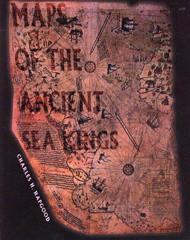
Maps of the Ancient Sea Kings
Evidence of Advanced Civilization in the Ice Age — The 1966 Book That Made the Piri Reis Map Famous
Find on Amazon →As an Amazon Associate, OverClassified may earn from qualifying purchases made through this link, at no extra cost to you.
Why This Is Essential Reading
Read it as the origin document, and read the cartographers for the answer. Maps of the Ancient Sea Kings is where the Piri Reis Antarctica claim comes from — and where the alternative-history genre learned one of its central moves: take a real artefact, find a feature that looks anomalous to a non-specialist, and build a lost civilisation on it. Charles Hapgood was not a fabricator; he worked from genuine maps, showed his reasoning and invited examination, which is why the refutation could be as specific as it is. The map's own marginal notes describe its compilation from about twenty earlier charts, which accounts for its accuracy; historians of cartography read the disputed southern coastline as South America bent east to fit the parchment, a documented convention; the Antarctic ice sheet has no human-scale window beneath it; and the crustal-displacement geology the whole argument rests on was superseded by plate tectonics almost as the book appeared. The Einstein foreword everyone cites was written in 1953, for a different book, before any of that. Read it with this site's Piri Reis file and Chariots of the Gods, which is how the claim reached the world.
Related Cases & Theories
Sources Cited
- Hapgood, Charles H. Maps of the Ancient Sea Kings: Evidence of Advanced Civilization in the Ice Age. Chilton Books, 1966; revised edition, Adventures Unlimited Press, Kempton, Illinois, 1996, 316 pp. ISBN-10 0932813429 / ISBN-13 9780932813428. amazon.com
- Open Library edition record, ISBN 0932813429 — bibliographic verification and cover-art source. openlibrary.org
- AbeBooks catalogue record, ISBN 9780932813428 — the Adventures Unlimited 1996 revised edition, its 316-page extent, and the publisher description of the Piri Reis, Hadji Ahmed and Oronteus Finaeus maps as evidence of an advanced worldwide civilisation predating ancient Egypt. abebooks.com
- Goodreads edition record — edition history from the 1966 Chilton first printing, and reader reception. goodreads.com
- ThriftBooks catalogue record — independent bibliographic listing and description. thriftbooks.com
- Wikipedia, "Charles Hapgood" — his 1904–1982 dates, his teaching career, the earth crust displacement hypothesis, the Einstein foreword and the scholarly assessment of his cartographic work. en.wikipedia.org
- Wikipedia, "Piri Reis map" — the 1513 chart, its 1929 rediscovery at Topkapı, Piri Reis's own marginal notes describing compilation from roughly twenty earlier sources including a lost Columbus map, and the cartographic reading of the disputed southern coastline. en.wikipedia.org
- Wikipedia, "Cataclysmic pole shift hypothesis" — the crustal-displacement framework the book depends on and its standing in modern geophysics. en.wikipedia.org
- Wikipedia, "Plate tectonics" — the theory established through the 1960s that accounts for continental movement and that superseded Hapgood's premise. en.wikipedia.org
- Wikipedia, "Portolan chart" — the medieval and early modern navigational chart tradition whose accuracy Hapgood treats as anomalous, and its documented development from accumulated pilot experience. en.wikipedia.org
- Wikipedia, "Oronce Finé" — the French cartographer whose 1531 world map, with its speculative Terra Australis, Hapgood read as an ice-free Antarctica. en.wikipedia.org
- Wikipedia, "Antarctic ice sheet" — the continental ice cover and its age, the physical fact with which the ice-free-Antarctica claim collides. en.wikipedia.org
- Wikipedia, "Chariots of the Gods?" — the 1968 book that took Hapgood's Piri Reis reading to a mass audience and recast it as evidence of aerial survey. en.wikipedia.org
Have corrections, additional research, or peer-reviewed sources? Help improve this entry.
Suggest an Edit