
The Piri Reis Map
In late 1929, staff cataloguing neglected manuscripts at Topkapı Palace in Istanbul found a fragment of gazelle-skin parchment covered in faded, colorful ink — a little over a third of a world map completed in 1513 by the Ottoman admiral and cartographer Piri Reis, and presented to Sultan Selim I in Cairo four years later. Piri Reis's own marginal notes describe compiling it from roughly twenty older source charts, including, in his words, a map drawn by "Colombo" in the western region — a document otherwise lost to history and known today only through this secondhand echo of it. The surviving fragment shows the Iberian coast, the west coast of Africa, and the Caribbean and eastern coast of South America in real, recognizable, and in places startlingly precise detail, trailing off at the bottom edge of the parchment into a long southern coastline that swings sharply east. Since the 1960s, that stray line has anchored one of the most durable claims in fringe archaeology: that it depicts the coast of Antarctica, mapped free of the ice that has covered it for millions of years — evidence, the argument runs, of a technologically sophisticated civilization lost to prehistory. The claim originates with retired college instructor Charles Hapgood's 1966 book Maps of the Ancient Sea Kings, and reached its largest audience two years later inside Erich von Däniken's Chariots of the Gods?, which folded it into a broader case for ancient extraterrestrial visitation. Historians of cartography who have actually studied the map's construction, its own marginal notes, and known 16th-century mapmaking conventions read that same coastline very differently: as the coast of South America itself, mapped with real accuracy as far as it went and then bent sharply to fit the remaining edge of the parchment — a documented, mundane compilation habit of the era, not a lost continent glimpsed through a vanished ice age.
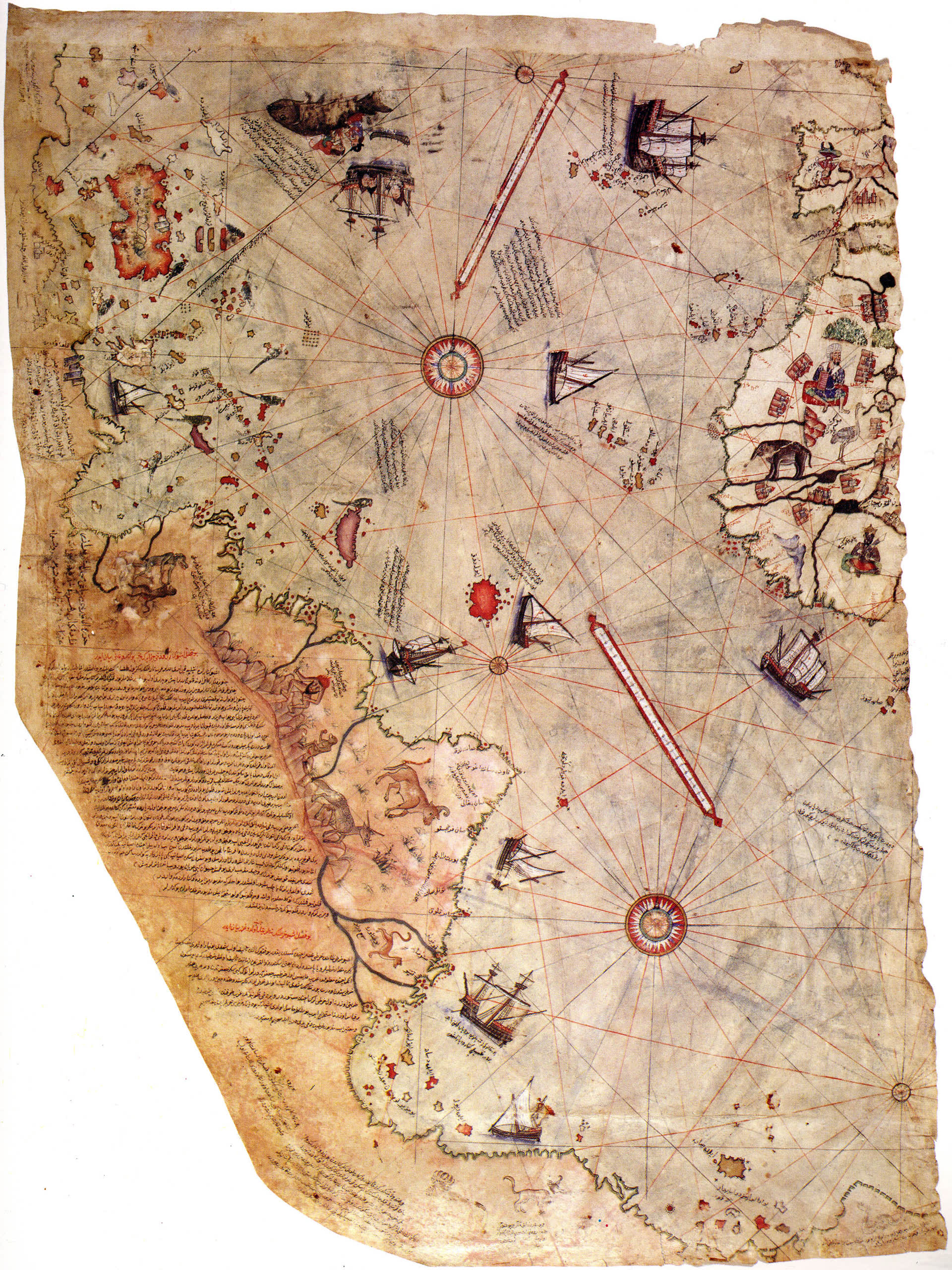
Theoretical Alignment
This file belongs to a recurring pattern in this site's Ancient Records archive: a real historical document, compiled by a real, credentialed, named historical figure, and rediscovered under real, well-documented circumstances — onto which a much later, much more sweeping claim has been grafted by writers working outside the relevant academic discipline. The Piri Reis map's own existence, provenance, and rediscovery are not in dispute; historians of cartography have studied the actual parchment, its ink, its marginal notes, and its likely source charts in detail. What is disputed is a single, specific interpretive leap first proposed more than four and a half centuries after the map was drawn: that one distorted coastline at the bottom of the surviving fragment depicts Antarctica, and depicts it ice-free. That interpretation does not originate with any cartographic historian, any polar geologist, or with Piri Reis's own extensive written explanation of his methods — it originates with a college history instructor working four decades ago, was picked up and amplified by a Swiss hotelier-turned-bestselling author with no relevant academic training, and has been rejected in every detailed scholarly treatment of the map published since.
Sensor & Instrumentation Detection Profile
As with every entry in this site's Ancient Records series, there is no modern sensor record; the relevant record here is the map itself and the ordinary, well-documented navigational instruments and drafting conventions of its era. Piri Reis worked in the portolan tradition — a Mediterranean charting method already three centuries old by 1513, built around a network of intersecting rhumb lines radiating from compass roses, drawn with magnetic-compass bearings and dead-reckoning distance estimates rather than mathematically projected latitude and longitude. A portolan chart is, by design, a compilation tool: a working navigator or a court cartographer redrew and combined whatever source charts were available, reconciling different scales, different reference meridians, and different levels of real geographic knowledge onto one sheet by eye and by hand, not by any uniform coordinate system. Piri Reis says as much directly in his own marginal notes, translated below, describing the map as an explicit synthesis of roughly twenty older charts of varying age, origin, and reliability. Nothing about the instrumentation or method available to a working Ottoman admiral in 1513 required, or is claimed by any credentialed historian to have required, knowledge of a coastline that would not be reached by sail for another three centuries.
The portolan method's own known limitations are, if anything, evidence against rather than for an unexplained level of precision. A typical portolan compass rose divides the horizon into thirty-two directions connected by a dense web of straight rhumb lines, letting a navigator lay a straightedge from a known position toward a destination and read off a compass bearing to steer — a system well suited to relatively short, well-traveled Mediterranean and Atlantic coastal routes, but one that accumulates real, compounding distortion over the very long distances and unfamiliar coastlines a world map like Piri Reis's had to compress onto a single sheet, since it has no consistent mathematical map projection underneath it to keep distant regions in correct relative scale and orientation. Compass bearings recorded at sea in this period were also subject to magnetic declination — the real, then poorly understood difference between magnetic north and true north, which varies by location and drifts over time — introducing further, unavoidable error into any chart built up from compass-and-distance dead reckoning rather than celestial or satellite positioning. A map assembled this way, from multiple source charts of differing quality, scale, and orientation, reconciled by eye rather than by any uniform coordinate mathematics, is exactly the kind of document expected to accumulate cumulative distortion the further it extends from its best-known, most frequently sailed regions — which is precisely where the disputed southern coastline sits, at the extreme, least-verified edge of the entire compilation.
Environmental & Geospatial Context
The map was compiled during the opening decades of the European Age of Discovery, a period in which the Ottoman Empire, though rarely credited for it in popular accounts, was an active and well-informed participant rather than a bystander. As a Mediterranean corsair captain serving under his uncle Kemal Reis before rising to independent command, Piri Reis operated in exactly the kind of naval environment — raiding, escorting, and fighting Venetian, Spanish, and other Christian shipping — in which captured, purchased, and copied European charts routinely changed hands; a captured Spanish or Portuguese portolan chart was ordinary maritime plunder, not an exotic acquisition requiring explanation. By 1516–17, the Ottoman Empire's conquest of the Mamluk Sultanate of Egypt under Sultan Selim I gave the empire direct strategic interest in the Red Sea and Indian Ocean trade routes that Portugal was simultaneously working to dominate by sea — the same competitive pressure that made accurate, up-to-date geographic intelligence valuable currency across every Mediterranean and Atlantic-facing power of the era, Ottoman included. The map's own surviving fragment reflects this moment precisely: a synthesis of Genoese, Portuguese, Arabic, and Ptolemaic geographic traditions, assembled by a serving naval officer with direct professional access to the era's most current charts, not a document that stands apart from its own historical moment in any way that requires an exotic explanation.
The wider strategic backdrop sharpens this point rather than complicating it. Vasco da Gama's 1497–99 voyage around the Cape of Good Hope had already broken the centuries-old Venetian and Mamluk monopoly on the overland and Red Sea spice trade between Europe and Asia, redirecting enormous wealth toward Lisbon and putting every power with a Mediterranean or Red Sea coastline — Mamluk Egypt first, and the Ottoman Empire immediately after it absorbed Egypt in 1517 — under direct commercial and strategic pressure to answer with better geographic intelligence of its own. Piri Reis's own career maps almost exactly onto this pressure: a 1513 world map compiled while Portuguese reports of the Americas and the Indian Ocean route were still fresh news across the Mediterranean, followed by direct Ottoman military engagement with Portugal over the same Red Sea and Indian Ocean routes once Piri Reis himself took command of the Ottoman Indian Ocean fleet decades later. None of this required, or has ever been argued by any credentialed historian to have required, intelligence beyond what an unusually well-connected, professionally motivated Ottoman naval officer could plausibly gather from captured charts, informants, and the same rapidly circulating reports of new discoveries that were reaching every literate court in Europe at the same moment.
Observer Credibility & Occupational Profile
Piri Reis was not an isolated eccentric producing a single unverifiable document. He was a career Ottoman naval officer with roughly three decades of active service by the time of his 1513 map, and, separately, the author of the Kitab-ı Bahriye ("Book of Navigation"), a practical sailing manual and portolan atlas of the Mediterranean he compiled in a first edition of 130 chapters around 1521 and an expanded 210-chapter edition in 1526. More than forty manuscript copies of the Kitab-ı Bahriye survive from the century and a half after his death, hand-copied by working Ottoman sailors and cartographers because the underlying navigational information — harbors, hazards, currents, sailing directions — was genuinely useful at sea, not because of any reputation for the miraculous. That is a very specific and testable kind of credibility: a body of technical work good enough that other professionals in the same trade kept copying it by hand for generations, evaluated on ordinary, falsifiable maritime terms. On the modern research side, the map's rediscovery and identification rests on Paul Kahle, a German orientalist and Semitic-languages scholar who published the first academic study of the fragment in 1931, and its most detailed modern academic treatment comes from Gregory McIntosh, an independent historian of early-modern cartography whose book-length study, published by the University of Georgia Press, corrected several of Kahle's original readings through direct examination of the parchment and its inscriptions. By contrast, the ice-free-Antarctica claim's originating author, Charles Hapgood, held no credential in cartography, geology, or Ottoman history; he taught history, anthropology, and general science topics at a succession of small New England colleges, and his Antarctica claim has never been independently replicated or endorsed by a working cartographic historian or polar geologist in the six decades since he first proposed it.
Historical Precedents & Archive Matches
This file joins a cluster of entries elsewhere in this site's Ancient Records archive built around the same underlying pattern: a real, verifiable ancient or early-modern artifact, correctly documented by the historians and scientists who actually study it, that a later fringe writer detaches from its real context and reframes as evidence of lost advanced technology or extraterrestrial contact. The Tulli Papyrus and the Dropa Stones are the closest structural matches — a real or claimed physical object, a documented (or in the papyrus's case, undocumented and never independently verified) provenance, and a specific "ancient technology" reading that does not survive scrutiny of the object's own actual content. The Mahabharata's Brahmastra passages offer the closest match in the shape of the debunking itself: a real, citable primary text, accurately quoted by fringe writers, whose specific "ancient nuclear weapon" reading collapses once the passage is read in its full literary and religious context rather than excerpted. Charles Hapgood's own 1966 book, notably, does not rest its case on the Piri Reis map alone — it makes structurally identical claims about the 1559 Oronteus Finaeus map and the undated Hadji Ahmed map, a pattern of applying the same interpretive method to multiple different documents that is itself a signal the method, not any one document, is the actual source of the anomaly.
Historical Background
Piri Reis: Corsair, Admiral, Cartographer
Piri Reis — born Hacı Muhiddin Piri, probably in Gelibolu (Gallipoli) on the Ottoman side of the Dardanelles, around 1470 — entered naval life as a young man under his uncle Kemal Reis, a celebrated Ottoman corsair captain who spent the 1480s and 1490s raiding Spanish and North African coastal shipping and fighting in the running Ottoman–Venetian naval wars of the period, including the 1499 Battle of Zonchio. Corsair service of this kind was, in effect, a maritime apprenticeship combined with an intelligence-gathering operation: captured ships yielded not just cargo but charts, and a working corsair captain built up a personal library of captured, copied, and traded navigational documents as a simple matter of professional practice, entirely independent of any official Ottoman cartographic program. When Kemal Reis died at sea in 1511, Piri Reis, by then an experienced captain in his own right, continued in Ottoman naval service, and it was in this period — drawing on decades of accumulated charts, his own firsthand Mediterranean sailing experience, and access to the era's rapidly circulating reports of the Spanish and Portuguese voyages of discovery — that he assembled the 1513 world map.
The map was not, on its own account, an entirely original survey; it was explicitly a synthesis, and Piri Reis said so in his own marginal notes (quoted in full below), naming roughly twenty older charts and reference works as his sources, including Ptolemaic world maps, an Arabic map of India, four recent Portuguese charts of Asia, and, for the western Atlantic, a map he attributed to "Colombo" — understood by every scholar who has studied the inscription, from Paul Kahle onward, to mean Christopher Columbus. No map by Columbus's own hand survives independently; the Piri Reis map is, in fact, the closest thing that exists to physical evidence of what a Columbus-era chart of the Caribbean actually looked like, filtered through Piri Reis's own redrawing. Gregory McIntosh's detailed 2000 study argues, based on the specific islands shown and their relative positions, that the underlying Columbus material reflects Columbus's second voyage (1493–96) rather than his third (1498–1500), correcting an earlier assumption in Kahle's original 1931 analysis.
Presentation to the Sultan and the Kitab-ı Bahriye
The Ottoman Empire's 1516–17 conquest of the Mamluk Sultanate, which brought Egypt, the Hejaz, and the holy cities of Mecca and Medina under Ottoman control, was the largest Ottoman territorial expansion of the young 16th century, and Piri Reis served with the fleet supporting that campaign. It was in Cairo in 1517, in the immediate aftermath of the conquest, that he presented his completed 1513 world map to Sultan Selim I — the presentation that placed the map in Ottoman royal hands and set it on the path, four centuries later, to the Topkapı Palace collection where it was rediscovered. Piri Reis went on to compile his best-known work, the Kitab-ı Bahriye, a practical portolan atlas and sailing guide to the Mediterranean organized as a continuous counter-clockwise circuit of the sea's coasts and islands, in a first 130-chapter edition around 1521, and a substantially expanded 210-chapter edition in 1526, commissioned through Grand Vizier Ibrahim Pasha and dedicated to Sultan Suleiman the Magnificent. The 1526 edition opens with an extended verse introduction on winds, storms, and celestial and compass navigation, and incorporates recent Portuguese and Spanish reports of the Americas and the Indian Ocean — further, independent documentary evidence that Piri Reis was working, throughout his career, as a well-informed professional synthesizing the best current information available to a Mediterranean naval officer of his era, not as the custodian of a secret or anomalous source. Each chapter of the finished atlas pairs a hand-drawn regional chart with practical sailing directions in prose — safe anchorages, freshwater sources, submerged rocks and shoals, prevailing local winds, and warnings about currents and hostile shores — the working-level detail a real captain needed to actually sail the routes described, and precisely the kind of granular, checkable content that is either right or wrong on the water, with no room for an unverifiable claim to hide inside it. A second, far more fragmentary world map by Piri Reis, dated 1528 and showing parts of Florida and the North American Atlantic coast reflecting the latest Portuguese discoveries, also survives at Topkapı Palace, underscoring that the 1513 map was one product of an active, ongoing, and entirely explicable cartographic career rather than an isolated anomaly.
Later Career, Downfall, and Execution
Piri Reis's career did not end with cartography. In 1547, by then an elderly but still active officer, he was appointed Kapudan-ı Hind, admiral of the Ottoman Indian Ocean fleet based at Suez, tasked with contesting Portuguese control of Red Sea and Indian Ocean trade. He recaptured the strategic port of Aden from the Portuguese in 1548, and in 1552 led an expedition against Portuguese positions in the Persian Gulf, capturing Muscat but failing, after a siege, to take the heavily fortified island of Hormuz. Rather than risk his fleet further, he withdrew to Basra, a decision his enemies at court characterized as cowardice, desertion, and bribery-motivated retreat with the fleet's plundered treasure. Sultan Suleiman the Magnificent, acting on these charges, ordered Piri Reis's execution; he was beheaded in Cairo in 1553, in his early eighties by most estimates of his birth year. Modern historians treat the specific charges against him as unproven and likely the product of court rivalries rather than an accurately reconstructed record of the Hormuz campaign's actual military logic. His charts and the Kitab-ı Bahriye outlived the controversy of his death by centuries, remaining in active practical use and hand-copied circulation among Ottoman sailors long after the political dispute that ended his life had been forgotten by anyone outside specialist Ottoman naval administration.
Complete Timeline
| Date | Event |
|---|---|
| c. 1470 | Piri Reis is born, probably at Gelibolu (Gallipoli), Ottoman Empire. |
| 1480s–1490s | Piri Reis serves at sea under his uncle, corsair captain Kemal Reis, raiding Christian Mediterranean shipping and fighting in the Ottoman–Venetian wars. |
| 1492 | Christopher Columbus makes his first transatlantic voyage under the Crown of Castile. |
| 1493–96 | Columbus's second voyage — per Gregory McIntosh's later research, the likely source of the Caribbean data on the Piri Reis map. |
| 1499 | Piri Reis takes part in the Battle of Zonchio during the Ottoman–Venetian War. |
| 1511 | Kemal Reis dies at sea; Piri Reis continues in Ottoman naval service as an independent captain. |
| 1513 | Piri Reis completes his world map, compiled from roughly twenty older source charts including a map attributed to Columbus. |
| 1516–17 | The Ottoman Empire conquers the Mamluk Sultanate of Egypt; Piri Reis serves with the supporting fleet. |
| 1517 | Piri Reis presents his 1513 world map to Sultan Selim I in Cairo. |
| c. 1521 | Piri Reis compiles the first, 130-chapter edition of the Kitab-ı Bahriye, a Mediterranean navigational atlas. |
| 1526 | An expanded, 210-chapter edition of the Kitab-ı Bahriye is completed for Grand Vizier Ibrahim Pasha and dedicated to Sultan Suleiman the Magnificent. |
| 1528 | Piri Reis completes a second, smaller world map showing the North American Atlantic coast; a fragment survives. |
| 1547 | Piri Reis is appointed Kapudan-ı Hind, admiral of the Ottoman Indian Ocean fleet. |
| 1548 | Piri Reis recaptures Aden from Portuguese forces. |
| 1552 | Piri Reis captures Muscat but fails to take Hormuz; he withdraws the fleet to Basra. |
| 1553 | Piri Reis is executed in Cairo on charges of bribery and desertion by order of Sultan Suleiman the Magnificent. |
| 1820 | Antarctica is sighted and recorded for the first time in the historical record, more than three centuries after the Piri Reis map was drawn. |
| Late 1929 | The surviving fragment of the map is found among neglected manuscript holdings at Topkapı Palace during a Rockefeller Foundation-funded survey. |
| 1931 | German orientalist Paul Kahle publishes the first scholarly identification and study of the map. |
| 1960 | Charles Hapgood obtains a letter from U.S. Air Force cartographic officers assessing the map's southern coastline against 1949 Antarctic seismic survey data. |
| 1966 | Hapgood publishes Maps of the Ancient Sea Kings, proposing the map shows an ice-free Antarctica mapped by a lost advanced civilization. |
| 1968 | Erich von Däniken repeats and popularizes Hapgood's claim in Chariots of the Gods?, reaching a mass international audience. |
| 2000 | Gregory McIntosh publishes The Piri Reis Map of 1513, the most detailed modern academic study, directly rejecting the Antarctica interpretation. |
| 2017 | The Piri Reis map is inscribed on UNESCO's Memory of the World Register. |
The Primary Source Document
Piri Reis's Own Marginal Notes (1513)
"From about twenty charts and Mappae Mundi — these are charts drawn in the days of Alexander, Lord of the Two Horns, which show the inhabited quarter of the world; the Arabs name these charts Jaferiye — from eight Jaferiyes of that kind and one Arabic map of Hind, and from the maps just drawn by four Portuguese which show the countries of Hind, Sind, and Chin geometrically drawn, and also from a map drawn by Colombo in the western region, I have extracted it. By reducing all these maps to one scale this final form was arrived at, so that this map of these lands is regarded by seamen as accurate."
Piri Reis, marginal inscription, 1513 world map (Topkapı Palace Museum, H. 1824); translation per Wikisource, "Piri Reis' Map"
This inscription is the single most important primary document in the entire controversy, because it is Piri Reis's own explicit, first-person account of his methodology — a compilation from named categories of existing charts, reduced to a common scale by hand — written in his own words on the map itself, four and a half centuries before anyone suggested it required any other explanation. Later inscriptions elsewhere on the surviving fragment, describing the region near the disputed southern coastline, are equally telling and rarely quoted by writers advancing the Antarctica claim: one legend describes the area as having very short winter days and very long summer ones, another describes it as "a waste... large snakes are found here... very hot," and a further note attributes reports of "white-haired monsters" and "six-horned oxen" there to Portuguese sources. A cartographer working from real information about a genuinely ice-free Antarctic coastline would have had no reason to label that coastline hot, snake-infested, and populated by exotic animals reportedly described by Portuguese informants — but a cartographer stretching his own accurate South American coastal data southward past where his real information ran out, and filling the gap with the era's stock imagery for unexplored tropical and subtropical frontiers, would produce exactly this combination.
Paul Kahle's 1931 Identification
The German orientalist Paul Kahle, examining the fragment shortly after its 1929 rediscovery, was the first scholar to identify it conclusively as Piri Reis's work, to translate its key marginal inscriptions, and to recognize the reference to a Columbus source map. Kahle's 1931 study established the map's basic scholarly framework — its date, its compiler, and its general sourcing — that all subsequent research, including the later corrections to some of his specific readings, has built on rather than replaced.
Gregory McIntosh's 2000 Academic Study
Gregory McIntosh's The Piri Reis Map of 1513, published by the University of Georgia Press, is the most thorough modern treatment of the document, combining close paleographic examination of the map's inscriptions with detailed comparison against known contemporary charts. McIntosh corrects Kahle's identification of which Columbus voyage the western data reflects, and directly and explicitly addresses the ancient-astronaut and lost-civilization readings of the map's southern coastline, concluding they are unsupported by the map's actual content, by Piri Reis's own stated methodology, and by comparison with other portolan charts of the same period showing the same general convention.
Confirmed Institutional & Archival Holdings
UNESCO's own register entry documenting the map's international documentary heritage status and historical significance.
PUBLICLY ACCESSIBLE INTERNATIONAL REGISTRYThe official museum record for the palace complex holding the map (catalogue no. H. 1824) within its Library and Museum collections.
OFFICIAL MUSEUM/GOVERNMENT ARCHIVEA complete English translation of every numbered legend and marginal note on the surviving map fragment, including the source-map inscription and the southern-coastline climate notes quoted above.
PUBLIC DOMAIN REFERENCE TEXTA condensed scholarly summary of McIntosh's book-length findings, addressing the map's real significance apart from the Antarctica claim.
PEER-ADJACENT ACADEMIC ARCHIVESearch Institutional & Academic Archives Directly
Evidence Assessment
Supporting the Map's Real Historical Significance
- The map itself, its provenance, its 1929 rediscovery, and its compiler's identity and career are all extremely well documented through institutional records, the compiler's own writings, and peer-reviewed academic study
- The surviving fragment's depiction of the Iberian coast, West Africa, and the Caribbean/South American coast is genuinely accurate and historically significant, preserving the earliest surviving cartographic echo of Columbus's own lost charts
- The map was inscribed on UNESCO's Memory of the World Register in 2017, reflecting its recognized status as a major, non-controversial artifact of Age-of-Discovery cartography
Undermining the Ice-Free-Antarctica Interpretation Specifically
- Piri Reis's own marginal notes describe the disputed southern coastline's climate as hot, with "large snakes" and short winter nights — the opposite of a description drawn from real knowledge of a polar landmass
- No credentialed cartographic historian has endorsed the Antarctica reading since it was first proposed in 1966; the map's most detailed modern academic study explicitly rejects it
- The claim's key supporting document, a 1960 U.S. Air Force officer's letter, compared the map to Antarctic subglacial bedrock topography rather than to any genuine ice-free coastline, and covered less than one percent of the region in question using a single 1949 seismic survey line
Comparative Analysis
The Oronteus Finaeus and Hadji Ahmed Maps
Charles Hapgood's 1966 book does not build its case on the Piri Reis map alone. He makes structurally identical "shows Antarctica accurately" claims about two other Renaissance-era maps — the 1531 Oronteus Finaeus world map and the undated Hadji Ahmed map — using the same core method: selectively rotating, rescaling, and reinterpreting a period map's own southern landmass until some subset of its features can be matched to some subset of a modern Antarctic coastline, while setting aside the features that do not match. That the same interpretive technique, applied by the same author, keeps finding the same lost civilization's fingerprints on three unrelated documents drawn by three different cartographers working a century and a half apart is itself a strong signal that the method generates the pattern, rather than discovering one that was already there.
A Different Kind of Ancient Record
Most entries in this site's Ancient Records archive concern a witnessed event — a light in the sky, a vision, a phenomenon observed and then recorded by someone present. This file is different: there is no disputed sighting or observation at its center, only a real document and a later interpretive claim about what one part of that document depicts. That makes it, in one sense, an easier file to resolve than most: the primary evidence (the map, its compiler's own explanatory notes, and its documented sourcing) is available for direct examination in a way a fifteen-century-old eyewitness account never can be, and the specialists who have actually examined it — working from the map's own words rather than a secondhand paraphrase of them — agree on what it does and does not show.
Material Analysis: The Parchment and the Atlas
The surviving fragment is drawn on gazelle-skin parchment, measuring roughly 90 by 63 centimeters — by every scholarly estimate, only the western portion of a considerably larger original sheet, the remainder of which has never been located and is presumed lost rather than hidden or suppressed. The ink and pigment work is consistent with ordinary Ottoman court workshop materials and technique for the period; no material analysis of the parchment, ink, or binding has ever suggested a date, origin, or production method inconsistent with 1513 Ottoman Istanbul. Piri Reis's own explanatory inscriptions are written directly on the map in Ottoman Turkish, in his own hand-attributed style, describing his sources and methods in the same practical, workmanlike register found throughout his separately surviving Kitab-ı Bahriye manuscripts — more than forty copies of which survive across collections in Istanbul, Europe, and the United States, containing collectively more than five thousand individual harbor charts and coastal maps. That large, independently attested body of ordinary, verifiable cartographic work is itself a form of material evidence: it documents, in enormous and mundane technical detail, exactly the kind of professional charting practice — compiling, correcting, and redrawing existing information from multiple sources — that fully accounts for the 1513 map's own construction, without requiring any recourse to a lost source civilization for which no comparable physical trace, in parchment, ink, tool, or any other medium, has ever been recovered anywhere.
Consistent with Ordinary 16th-Century Ottoman Origin
- Parchment, ink, and drafting technique match known Ottoman court cartographic workshop practice of the period
- The map's own marginal notes describe an ordinary compilation process from named categories of existing charts
- The same compiler's separately surviving, independently verified body of work (the Kitab-ı Bahriye) demonstrates the identical sourcing-and-redrawing method at much greater scale and detail
No Physical Trace Supporting a Non-Human or Pre-Ice-Age Origin
- No source map, tool, instrument, or fragment attributable to any pre-Ice-Age or non-human civilization has ever been recovered anywhere in connection with this or any related document
- The claimed underlying "ancient source maps" Hapgood proposed exist only as his own reconstructions, arrived at by assuming and then subtracting hypothetical copying errors from the Renaissance-era maps that do survive
- No independent replication of Hapgood's reconstructed coastline match has ever been published by a working cartographer or polar geologist
The Paleocontact / Ancient-Astronaut Interpretation
The claim that the Piri Reis map depicts an ice-free Antarctica originates specifically with Charles Hapgood's 1966 book Maps of the Ancient Sea Kings: Evidence of Advanced Civilization in the Ice Age. Hapgood, building on earlier speculation by civil engineer and amateur archaeologist Arlington H. Mallery, argued that the map's disputed southern coastline correlated closely with the subglacial bedrock topography of Antarctica's Queen Maud Land, and that this correlation could only be explained if the coastline had been surveyed and mapped by a technologically advanced civilization before the last major glaciation buried it in ice — a civilization whose own records, in Hapgood's account, were subsequently lost, with only garbled copies-of-copies surviving into the Renaissance charts that Piri Reis and other cartographers unknowingly incorporated. Hapgood's central piece of supporting evidence was a July 1960 letter from officers of the U.S. Air Force's 8th Reconnaissance Technical Squadron, who wrote, after Hapgood supplied them with his own reconstructed overlay of the map, that the southern coastline's agreement with a 1949 Swedish-British-Norwegian Antarctic Expedition seismic survey was "reasonable" and represented "the most logical, and in all probability, the correct interpretation of the map." That letter, still the single most frequently quoted piece of "evidence" in popular retellings of the claim, was a personal assessment by cartographic officers responding to material Hapgood himself had already interpreted for them, not an independent scientific study, and it compared the map to Antarctic bedrock topography beneath the ice sheet — not to any known or claimed ice-free coastline, a distinction Hapgood's own argument required blurring to work at all.
The claim reached its largest audience two years later when Erich von Däniken repeated it, with embellishments including the claim that the map showed specific Antarctic mountain ranges not confirmed by modern sonar and seismic survey until the 20th century, in his 1968 international bestseller Chariots of the Gods?, folding Hapgood's already-strained cartographic argument into a much broader case for ancient extraterrestrial visitation. Von Däniken's own scholarly credentials in cartography, geology, or Ottoman history were nonexistent, and his book has been repeatedly documented, including by this site's own Essential Reading coverage, as containing numerous independently verifiable factual errors and unsupported claims across its other case studies. The claim has since become a fixture of popular "lost civilization" and ancient-astronaut media — frequently repeated in television documentaries, online articles, and video content — almost always without engaging Piri Reis's own marginal notes describing the disputed coastline's climate, without citing any cartographic historian who actually endorses the reading, and without acknowledging that Hapgood applied the identical method to two other, unrelated Renaissance maps in the same book.
The Mainstream Cartographic & Scientific Interpretation
The Distorted South America Case
Historians of cartography who have studied the map's actual construction read the disputed southern coastline as a distorted continuation of the coast of South America, not a separately mapped Antarctic coastline. The mechanism is a well-documented, mundane feature of period portolan cartography: as Piri Reis worked his way down the eastern coast of South America using genuinely good source information, he approached the physical bottom edge of his gazelle-skin parchment before running out of geographic data to record. Rather than begin a new sheet or leave the coastline incomplete, he did what other compilers of the era routinely did when a chart's working surface ran out before its subject matter did — he bent the coastline to follow the parchment's remaining edge, continuing it sharply eastward rather than south, and filled the resulting extension with the era's stock imagery for unexplored frontier regions (extreme climate variation, exotic animals, reports "written" by Portuguese informants) rather than with any specific new geographic survey data. Rotated back to a conventional north-up orientation and compared against a modern map of Argentina and Patagonia, features on the disputed coastline align credibly with real Argentine geography — the Gulf of San Matías and Península Valdés among them — while roughly 1,200 miles of genuine Argentine coastline that ought to appear between the accurately mapped Brazilian coast and the disputed southern extension simply does not, exactly as expected if the map compressed and redirected that stretch of coastline to fit the parchment rather than omitting South America's own coast entirely in favor of a separately surveyed Antarctica.
The Terra Australis Convention
A related and complementary explanation, discussed by several cartographic historians alongside the parchment-edge argument, is that the map's southern extension also reflects the period convention of depicting Terra Australis Incognita — a hypothesized southern landmass, inherited from classical geography and appearing on many 16th-century maps in speculative, schematic form, believed necessary to "balance" the known northern continents rather than based on any actual southern survey. A cartographer working near the edge of his real information, in an era when a large unmapped southern continent was a standing cartographic assumption rather than a settled absence, had every reason to extend a coastline speculatively southward and eastward rather than simply stop drawing — producing a result that later observers, primed to look for a real Antarctic coastline, could selectively match against actual Antarctic topography while ignoring the much larger set of features that do not match at all.
The Ice-Core and Glaciological Case Against Any Human-Era Ice-Free Window
Independent of the cartographic argument, the glaciological record rules out an ice-free Antarctic coastline within any period a human cartographer, ancient or otherwise, could plausibly have surveyed. Geological evidence places the initial formation of the East Antarctic Ice Sheet in the late Eocene, roughly 34 million years ago, with substantial further expansion and stabilization through the subsequent Oligocene — tens of millions of years before the first anatomically modern humans existed, let alone any civilization capable of producing accurate coastal charts. The West Antarctic Ice Sheet saw some documented retreat during a warm interval of the early Pliocene, roughly three to five million years ago, but even that retreat long predates the emergence of the genus Homo, and it did not affect the much larger, much older East Antarctic Ice Sheet, which shows no evidence of significant decline across the same period. The 2024–25 Beyond EPICA drilling project, led by the British Antarctic Survey and a consortium of European research institutions, extracted a continuous ice core from Antarctica's Little Dome C site preserving an unbroken 1.2-million-year climate record — direct physical evidence of continuous ice cover at that site across the entire span of human evolutionary history, with no gap, interruption, or ice-free interval of any kind. No credible reading of the ice-core, geological, or glaciological record permits an ice-free Antarctic coastline at any point since well before the human lineage itself existed, which independently rules out the Piri Reis claim on physical grounds even before the cartographic argument is considered at all.
Why the 1960 Air Force Letter Does Not Rescue the Claim
Geologist Paul V. Heinrich, in a detailed published critique of Hapgood's evidentiary chain, identifies the specific technical error underneath the 1960 letter that Hapgood treated as independent military corroboration. Ohlmeyer and Burroughs compared Hapgood's overlay to a map of Antarctica's subglacial bedrock topography — the shape of the rock surface currently buried under as much as several kilometers of ice, reconstructed from seismic survey data — not to any actual ice-free coastline. Removing that much ice from a continental landmass does not simply reveal the bedrock as it now stands: it triggers isostatic rebound, in which the crust itself rises, potentially by hundreds of meters in places, once the enormous weight of the ice sheet pressing it down is gone. A true ice-free Antarctic coastline from any era would sit at a different elevation and a different position than today's ice-covered bedrock profile, a distinction Ohlmeyer's letter never addresses. Compounding the problem, the seismic line the 1949 Norwegian-British-Swedish Antarctic Expedition had actually surveyed, the sole dataset the comparison rested on, covered a small fraction of the vast coastline in question — nowhere near enough independent data points to make the kind of confident visual match Hapgood's letter claimed. A single non-peer-reviewed letter, responding to an already-interpreted overlay, built on a bedrock-versus-surface conflation and a thin, single-line dataset, is not a rigorous independent confirmation by any standard cartographic historians or earth scientists would recognize — and no such rigorous confirmation has been produced by anyone in the sixty-plus years since.
Five Observables Assessment
The Five Observables framework, developed decades later by former AATIP director Luis Elizondo to classify modern UAP performance characteristics that exceed known technology, is included here for structural consistency with the rest of OverClassified's case files, but does not meaningfully apply to a static 16th-century document with no flight characteristics, propulsion signature, or direct observational encounter of any kind.
Assessment: As with this site's other pre-modern and documentary files, the Five Observables framework is the wrong instrument here. Its inclusion should not be read as suggesting genuine exotic-performance or non-human-technology evidence exists for this case.
Conventional Explanation Candidates
Three candidates are assessed below.
Distorted South American Coastline, Bent to Fit the Parchment Edge
Highly PlausibleThe leading explanation among cartographic historians who have directly studied the map's construction: Piri Reis's genuinely accurate South American coastal data ran out near the bottom of his available parchment, and the coastline was bent eastward to follow the sheet's remaining edge, a documented compilation habit of the era. Rotated and compared to real Argentine geography, several features align credibly with the actual coast, while roughly 1,200 miles of real coastline that should appear is simply missing — exactly the signature this explanation predicts.
Conflation with the Legendary Terra Australis Convention
Plausible (Contributing Factor)A complementary, non-exclusive explanation: as the map's real information ran out, its compiler likely also drew on the period's standing cartographic convention of a speculative, unsurveyed southern continent, filling the gap with generic frontier imagery rather than specific new geographic data — consistent with the disputed coastline's own marginal notes describing hot climate and exotic wildlife rather than ice.
A Genuine, Accurately Surveyed, Ice-Free Antarctic Coastline
ImplausibleContradicted on two independent grounds: the map's own marginal notes describe the disputed coastline as hot and populated by snakes rather than icebound, and the glaciological record — including a continuous 1.2-million-year ice core recovered by the Beyond EPICA project — shows no ice-free interval at Antarctica within any period human cartographers could plausibly have surveyed. No cartographic historian or polar geologist has endorsed this reading since it was first proposed in 1966.
Why "Debunked"
This file receives a DEBUNKED classification — applied specifically to the ice-free-Antarctica claim, not to the Piri Reis map itself, whose real historical existence, provenance, authorship, and significance are extremely well documented and entirely uncontroversial. The claim fails on multiple, independent lines of evidence rather than a single weak point: Piri Reis's own marginal notes describe the disputed coastline in terms — hot climate, exotic snakes, short winter nights — that directly contradict a polar reading, and are almost never quoted by writers advancing the Antarctica interpretation; the map's most detailed modern academic study, by a specialist historian of cartography with no stake in either side of the popular debate, explicitly examined and rejected the claim; the claim's key piece of supporting "evidence," a 1960 U.S. Air Force letter, was a personal assessment of material the claim's own originator had already pre-interpreted, based on a single seismic survey line covering a small fraction of the region in question, and compared to subglacial bedrock topography rather than any actual ice-free coastline; and the glaciological record independently rules out any ice-free Antarctic coastline within the entire span of human evolutionary history, let alone within reach of a 16th-century Ottoman admiral's source charts. No serious cartographic historian, polar scientist, or Ottoman studies specialist has endorsed the Antarctica reading in the sixty years since Charles Hapgood first proposed it, and the claim's own popularizer, Erich von Däniken, has an extensively documented record of unsupported factual claims across the rest of his work. This is a case, consistent with this site's standing editorial approach, where the real, mainstream explanation is well-established and genuinely decisive rather than a matter of ongoing legitimate dispute — the map remains a genuinely remarkable and historically important document precisely because of what it actually is, not because of what a later, unrelated claim asserted about it.
Related Entries
Further Reading — Recommended Literature
The Piri Reis Map of 1513
The definitive modern academic study of the map, correcting earlier readings and directly addressing and rejecting the Antarctica interpretation.
Maps of the Ancient Sea Kings
The 1966 book that originated the ice-free-Antarctica claim, read here as the primary source of the theory under investigation, not an endorsement of it.
Chariots of the Gods?
The 1968 bestseller that carried Hapgood's claim to a mass international audience as part of a broader ancient-astronaut argument.
Piri Reis and Turkish Mapmaking after Columbus
A scholarly study of Piri Reis's broader cartographic career and the Ottoman mapmaking tradition he worked within.
A History of the World in 12 Maps
A wider history of world cartography for context on the portolan tradition and how period maps encoded their makers' own limits of knowledge.
DISCLOSURE: Some links above are affiliate links. If you purchase through them, OverClassified receives a small commission at no additional cost to you. This helps support independent research.
Essential Viewing
Piri Reis, a Revolutionary Cartographer | Pioneers Episode 1
TRT World — a biographical documentary on Piri Reis's life and cartographic career.
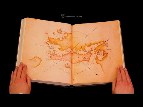
The Kitâb-i Bahriye: Piri Reis' Book on Navigation
Ziereis Facsimiles — a close, page-by-page look at a facsimile edition of Piri Reis's own navigational atlas.
Sources
- "Piri Reis map." Wikipedia. en.wikipedia.org
- "Piri Reis." Wikipedia. en.wikipedia.org
- "Kitab-ı Bahriye." Wikipedia. en.wikipedia.org
- "Antarctic ice sheet." Wikipedia. en.wikipedia.org
- "Piri Reis' Map." Full translated legends and marginal inscriptions. Wikisource. en.wikisource.org
- "The Piri Reis World Map (1513)." UNESCO Memory of the World Register. unesco.org
- "Turkey: World Map by Piri Reis." Nomination Form, International Memory of the World Register. UNESCO. media.unesco.org
- "Topkapı Palace Museum." Republic of Türkiye, Ministry of Culture and Tourism. muze.gen.tr
- McIntosh, Gregory C. "The Piri Reis Map of 1513 is Important Because..." ResearchGate. researchgate.net
- McIntosh, Gregory C., with Norman J. W. Thrower. The Piri Reis Map of 1513. University of Georgia Press, 2000.
- Soucek, Svat. Piri Reis and Turkish Mapmaking after Columbus: The Khalili Portolan Atlas. Nour Foundation / Oxford University Press, 1996.
- Hapgood, Charles H. Maps of the Ancient Sea Kings: Evidence of Advanced Civilization in the Ice Age. Chilton Books, 1966.
- von Däniken, Erich. Chariots of the Gods? Berkley, 1968/1984 English ed. (ISBN 0425074811).
- Cuoghi, Diego. "The Mysteries of the Piri Reis Map." diegocuoghi.com
- Heinrich, Paul V. "Fingerprints of the Gods, Re: Piri Reis Map." Hall of Maat. hallofmaat.com
- "Piri Reis Map: Unraveling the Myths and Realities of an Ancient Chart." IFLScience. iflscience.com
- "Historic drilling campaign reaches ice more than 1.2 million years old." British Antarctic Survey. bas.ac.uk
- Rosen, Rebecca. "The Deepest Antarctic Ice Core Yet Unlocks 1.2 Million Years of Earth's Climate History." Gizmodo. gizmodo.com
- "Does the Piri Reis map of Antarctica really show the continent before it was covered in ice?" Curiosmos (full text of the 1960 Ohlmeyer/8th Reconnaissance Technical Squadron letter, with critical context). curiosmos.com
- "The Piri Reis World Map (1513)." 1001 Inventions. 1001inventions.com
- "Piri Reis, a revolutionary cartographer | Pioneers Episode 1." TRT World, YouTube. youtube.com
- "THE KITÂB-I BAHRIYE: PIRI REIS' BOOK ON NAVIGATION." Ziereis Facsimiles, YouTube. youtube.com
- "Piri reis world map 01.jpg." File description and licensing. Wikimedia Commons (Public Domain). commons.wikimedia.org
See something inaccurate? Have additional information or sources?
Suggest an Edit →Last Updated: August 2026