
The Nazca Lines as "Landing Strips"
Scratched into the stony desert floor of southern Peru between roughly 500 BCE and 500 CE, the geoglyphs known today as the Nazca Lines — more than 800 individual straight lines, some running dead-straight for miles; some 300 geometric trapezoids, triangles, and spirals; and around seventy figurative drawings of animals, plants, and human-like beings — are legible in full only from high above the pampa. That single fact has made them one of the most durable magnets in fringe archaeology for a specific claim: that they are not ceremonial art at all, but an airfield, built or used by visitors from another world who needed a landing surface large enough for their craft. The claim did not originate with Erich von Däniken, though his 1968 bestseller Chariots of the Gods? is by far its most widely read vehicle; it traces to a single paragraph in the October 1955 issue of Fate magazine, written by James W. Moseley, and was carried into mass European readership five years before von Däniken by French writers Louis Pauwels and Jacques Bergier. Archaeologists who have actually excavated at the site, dated its wooden survey stakes, and physically reproduced its figures from ground level using nothing more than cord, wooden pegs, and simple sightlines read the lines very differently: as ceremonial walkways and ritual markers tied to a desperate desert culture's water and fertility cults, built by people who never needed to leave the ground to make them, on a surface too soft and too shallow to have ever borne a landing spacecraft in the first place. The mathematician who devoted six decades of her life to mapping and defending the site, Maria Reiche, put the rebuttal more bluntly than any peer-reviewed paper has: asked about von Däniken's landing-strip theory, she is reported to have said, "I'm afraid the spacemen would have gotten stuck."
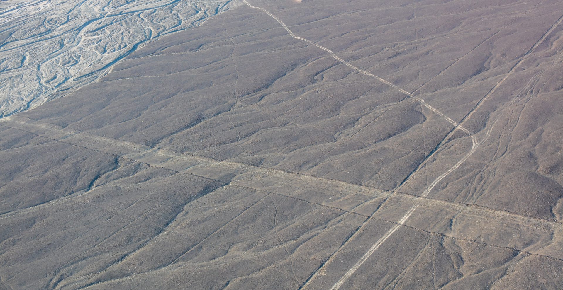
Theoretical Alignment
This file follows the same recurring pattern as several other entries in this site's Ancient Records archive: a real, extensively studied archaeological site, whose own excavators, dating evidence, and physical reconstruction attempts are not seriously disputed, has had a much later, much more sweeping claim grafted onto it by writers working entirely outside archaeology, geology, or Andean studies. The Nazca Lines' existence, age, and construction method are not in question. What is disputed is a single interpretive leap, first published more than fourteen centuries after the last lines were drawn: that the geoglyphs' true purpose was aviation infrastructure for non-human visitors. That reading does not originate with any archaeologist who has excavated at Nazca, with the mathematician who spent six decades mapping the site by hand, or with any of the aerial-survey teams who have spent the past two decades systematically re-photographing it — it originates with a UFO-magazine contributor working from a desk in the United States, was carried into mass European readership by two French journalists with no archaeological training, and was popularized worldwide by a Swiss hotel manager with a documented fraud conviction and no relevant academic credential of any kind. Genuine, ongoing scholarly disagreement does exist about the Lines' real purpose — whether the dominant function was ceremonial procession, water and mountain-deity worship, calendrical marking, or some combination that varied by geoglyph type — but that disagreement sits entirely within mainstream archaeology and archaeoastronomy, among researchers working from excavated evidence, statistical analysis, and each other's published, peer-reviewed rebuttals. None of the real contenders in that debate involves anyone leaving the ground.
Sensor & Instrumentation Detection Profile
Unlike many entries in this site's Ancient Records series, the instrumentation record here is unusually rich, because the Nazca Lines have been the direct subject of nearly a century of escalating remote-sensing technology, each generation of which has made the "requires an aerial vantage point to build" version of the landing-strip argument harder to sustain rather than easier. The earliest instrumented study was ordinary radiocarbon dating: archaeologists recovered wooden stakes driven into the ground at the terminus of several lines, and dating those stakes — rather than any assumption about who might have used the lines — anchors the accepted construction window of roughly 500 BCE to 500 CE squarely within the region's documented Paracas and Nazca cultural sequence. Paul Kosok and Maria Reiche conducted their own foundational survey work with plane tables, tape measures, and compass bearings taken from the ground and from modest elevations such as nearby hillsides and a small stepladder Reiche carried into the desert for decades — not from an aircraft, and certainly not from orbit. Aerial photography entered the record only as a documentation tool, not a construction requirement: the geoglyphs' scale-spanning visibility from commercial aircraft flying over southern Peru in the 1920s and 1930s is what first drew wider public attention to them, decades after local ground-level awareness of at least the smaller markings already existed.
The modern instrumentation record has moved well past hand-drawn field sketches. In 2008–09, Italian remote-sensing scientists Rosa Lasaponara and Nicola Masini of Italy's National Research Council (CNR) used QuickBird satellite multispectral imagery combined with ground-based geomagnetic survey to identify a previously unrecorded buried adobe pyramid near the Rio Nazca, demonstrating that satellite remote sensing could resolve archaeological features invisible to a ground observer without ever requiring the site's original builders to have possessed anything comparable. A Yamagata University team identified roughly 100 additional, previously unrecorded geoglyphs between 2011 and 2012 using aerial and satellite survey; a 2019 collaboration between Yamagata University and IBM Japan applied early machine-learning image classification to identify a further 143 geoglyphs; and a 2024 study published in the Proceedings of the National Academy of Sciences, led by Masato Sakai's Yamagata University team working with IBM's Thomas J. Watson Research Center, used a deep-learning model trained on drone imagery to identify 303 further figurative geoglyphs in just six months — nearly doubling the roughly 430 figurative designs catalogued over the preceding century of fieldwork. Every one of these instruments — radiocarbon counters, QuickBird's multispectral sensor, drone-mounted cameras, and a convolutional neural network — exists to help modern researchers find geoglyphs that are difficult to see even from directly overhead in a low-flying aircraft; none of it is evidence that the Nazca themselves needed, used, or had access to anything remotely comparable when they built the lines in the first place.
Environmental & Geospatial Context
The Nazca Lines sit on the Pampa Colorada, an extraordinarily flat, stony, rainless plateau in Peru's Ica Region, roughly 400 km south of Lima, between the modern towns of Nazca and Palpa. The desert floor here is coated in a thin layer of dark, reddish-brown pebbles rich in iron and manganese oxides — a natural "desert varnish" produced by millennia of oxidation under intense sun — sitting atop a lighter, yellowish-grey subsoil. That two-tone geology is the entire physical mechanism behind the Lines: removing the dark surface stones by hand exposes a sharp, high-contrast pale stripe beneath, visible for a very long time in a climate that receives, on average, only a few minutes of rain per year. Paleoclimate research led by Markus Reindel of the University of Bonn and Bernhard Eitel of the University of Heidelberg, based on buried loess deposits, found that the region supported considerably more grassland vegetation between roughly 9000 and 3000 BCE, before entering a long desiccation trend; by around 300 CE, in the middle of the Nazca culture's own occupation of the valley, the climate had turned progressively and severely drier, and by roughly 650 CE the higher-elevation settlements in the surrounding mountains had been abandoned outright. That same research team's excavations recovered Spondylus shells — a warm-water mollusc found only far to the north, near modern Ecuador, and long associated across the Andes with water-fertility ritual — alongside altar platforms bearing sacrificial offerings directly beside several geoglyphs, physical evidence tying the site to real ritual practice rather than any incidental byproduct of unrelated activity.
This same hyper-arid, almost windless environment is also the reason the Lines have survived at all, and it is a double-edged fact for the landing-strip claim rather than a supporting one. An environment stable and undisturbed enough to preserve shallow, hand-scraped surface markings for two and a half thousand years is, by the same token, an environment that would have preserved any physical trace of a genuine, repeated aircraft landing operation just as durably — compacted or gouged soil inconsistent with the surrounding undisturbed desert varnish, scorch or heat-discoloration marks from any kind of propulsion exhaust, displaced surface material inconsistent with the deliberate, uniform stone-clearing pattern seen everywhere else on the pampa, or debris of any kind. None of that has ever been reported by any archaeologist who has worked the site, and the region's extreme aridity and near-total absence of wind erosion make "it must have weathered away" an unusually weak excuse here compared to almost any other archaeological setting on Earth.
Observer Credibility & Occupational Profile
The credibility gap between the two sides of this claim is unusually stark even by this site's own standards. The claim's originator, James W. Moseley, was a UFO-periodical publisher with no training in archaeology, geology, or any related discipline, whose own later career — running the gossip-driven newsletter Saucer Smear and engineering UFO hoaxes of his own — is documented elsewhere on this site as that of a self-aware prankster as much as a sincere researcher. Louis Pauwels, who carried the claim into a much larger readership, was a French journalist and magazine founder with a background in occultism and popular esotericism, not archaeology; his co-author Jacques Bergier was a wartime chemical engineer and French Resistance intelligence operative turned science-fiction writer, credentials relevant to neither Peruvian prehistory nor Andean archaeoastronomy. Erich von Däniken, whose 1968 Chariots of the Gods? reached the largest audience of the three, was a Swiss hotel manager with no university training in any relevant field and a 1970 Swiss fraud and embezzlement conviction over falsified business records, facts this site's own Key Figures coverage documents in detail.
Set against that is a century of credentialed, publicly checkable fieldwork. Toribio Mejía Xesspe, the Peruvian archaeologist who first scientifically documented the lines on foot in 1926–27 and formally presented his findings to an archaeological congress in Lima in 1939, trained under Julio C. Tello, the founder of Peruvian scientific archaeology. Paul Kosok held a doctorate in history and taught at Long Island University, arriving in Peru in 1939 specifically to study ancient irrigation systems before recognizing the Lines' broader significance in 1941. Maria Reiche held a mathematics degree from the Technical University of Hamburg and applied it directly to measuring and mapping the geoglyphs across nearly six decades of fieldwork, ultimately earning Peruvian citizenship in 1992 in recognition of her work. Anthony Aveni, the Russell Colgate Distinguished University Professor of Astronomy and Anthropology at Colgate University and a founding figure of the discipline of archaeoastronomy, has published more than thirty books and three cover articles in Science. Johan Reinhard holds a doctorate in anthropology from the University of Vienna and is an Explorer-in-Residence at the National Geographic Society, independently credentialed by his own discovery of multiple preserved high-altitude Inca sacrificial burials in the Andes, including the mummy known as Juanita. Rosa Lasaponara is a Research Director at Italy's National Research Council specializing in satellite remote sensing. Kenneth Feder, Professor Emeritus of Anthropology at Central Connecticut State University, has spent a career specifically documenting how pseudoarchaeological claims like this one are constructed and why they persist. Every one of these credentialed researchers, working independently across nine decades and several distinct academic disciplines, arrives at a ground-built, non-aviation reading of the same physical evidence.
Historical Precedents & Archive Matches
This file joins a recurring pattern already established elsewhere in this site's Ancient Records archive: a real, well-documented ancient site or artifact, correctly studied by the archaeologists and scientists who actually work on it, that a later fringe author detaches from its real context to argue for lost advanced technology or extraterrestrial contact. The Piri Reis Map is the closest structural match in how the claim itself spread: a single non-specialist author's interpretation (there, Charles Hapgood's 1966 Antarctica reading) was picked up and mass-marketed two years later by the same author, Erich von Däniken, in the same 1968 book that carries the Nazca landing-strip claim to its largest audience — making Chariots of the Gods? itself a recurring node across multiple entries in this archive rather than a one-off source. The Saqqara Bird and the Baghdad Battery offer the closest match in the shape of the debunking itself: a real artifact whose claimed "impossible" function (flight, in the Saqqara Bird's case; electrical generation, in the Baghdad Battery's) has been directly tested through physical reconstruction by researchers working with only the tools and materials actually available to its original makers, with results that fail to support the exotic reading. The Nazca file adds a third recurring element found in a subset of these entries: a documented, multi-step chain of transmission — an obscure original claim, a mid-century popularization by writers outside the relevant field, and a single mass-market bestseller that fixes the claim in public memory for good — that closely mirrors how the Dropa Stones story and the Mahabharata "nuclear weapon" reading each reached English-language audiences elsewhere in this archive.
Historical Background
The Nazca and Their Desert Canvas
The Nazca culture flourished along Peru's arid southern coast, in the river valleys of the Rio Grande de Nazca drainage and the neighboring Ica Valley, from roughly 100 BCE to 800 CE, developing out of the earlier Paracas culture that had itself produced some of the region's oldest geoglyphs from around 500 BCE onward. Archaeologists divide the Nazca sequence into Proto-Nazca (roughly 100 BCE–1 CE), Early Nazca (1–450 CE), Middle Nazca (450–550 CE), and Late Nazca (550–750 CE) phases, tracking a society organized not as a single centralized state but as a loose network of local chiefdoms, led by a priestly and warrior elite, that periodically acted in concert — most visibly at Cahuachi, a sprawling, largely unbuilt-upon ceremonial complex of more than forty earthen mounds and plazas that functioned as a pilgrimage center rather than a permanent city, its population expanding and contracting around specific ritual calendars rather than daily residence. Nazca artisans produced technically extraordinary polychrome pottery, in places employing more than a dozen distinct pigment colors on a single vessel, and finely woven textiles, both decorated with the same repertoire of stylized animal, plant, and mythological imagery that recurs in the ground-drawn geoglyphs — direct, checkable evidence that the figures scratched into the desert floor came from the same visual and religious vocabulary as the culture's ordinary, small-scale craft production, not from an imported or externally supplied design source. The civilization's eventual decline, beginning around 500 CE and largely complete by 750 CE, is now understood by environmental archaeologists to be linked to a severe El Niño-driven flooding episode, compounded by the Nazca's own progressive clearing of the region's native huarango (Prosopis pallida) trees to expand irrigated maize and cotton cultivation — removing a root system that had stabilized the valley floor against exactly the kind of catastrophic erosion that followed.
Rediscovery and Early Investigation
Some of the smaller, more visible markings on the pampa were almost certainly known to local residents of the Nazca region for generations before any formal study, but the first documented scientific attention came from Peruvian archaeologist Toribio Mejía Xesspe, a student of Julio C. Tello, who observed lines from the surrounding foothills while conducting unrelated fieldwork on Paracas burial sites in 1926 or 1927. Mejía Xesspe concluded, correctly by modern archaeological consensus, that at least some of the markings functioned as sacred ceremonial pathways, and formally presented that interpretation to an archaeological congress in Lima in 1939 — more than a decade before the claim would first surface that the same markings were built for spacecraft. Wider public attention followed a different route: as commercial aviation over southern Peru expanded through the 1920s and 1930s, pilots and passengers began noticing the ground patterns from the air, generating popular newspaper coverage that framed the site as an unsolved "mystery" well before any rigorous scientific study caught up to the press interest.
That rigorous study arrived with Paul Kosok, an American historian at Long Island University who came to Peru in 1939 to study ancient irrigation canal systems, a research interest that led him to the Nazca pampa in search of water-management infrastructure rather than art or astronomy. On June 22, 1941 — the day after the Southern Hemisphere's winter solstice — Kosok, working at the end of a long day of fieldwork, looked up to see the setting sun align directly with one of the long straight lines he had been studying, and proposed that at least some lines might mark solstice positions, memorably calling the pampa "the largest astronomy book in the world." Kosok's Peruvian research assistant, the young German mathematician Maria Reiche, took up the astronomical hypothesis and made it her life's work: after Kosok's own research obligations pulled him elsewhere, Reiche stayed in Peru, and beginning in 1946 spent weeks at a time living directly on the desert pampa, personally sweeping centuries of windblown sand and grit off individual lines with a household broom, mapping their courses by hand with tape measure and compass, and lobbying the Peruvian government for the site's legal protection. She was granted Peruvian citizenship in 1992 in recognition of that work, published her complete scientific findings as Contributions to Geometry and Astronomy in Ancient Peru in 1993 at age ninety, and died in Lima in June 1998; the local airport at Nazca is today named in her honor.
Construction: How (Not) to Build a "Runway"
The construction method behind the Lines has been directly, physically tested, and it categorically does not require anyone to leave the ground at any stage. Archaeological surveys have recovered wooden stakes driven into the earth at the endpoints of a number of lines; radiocarbon dating of this wood anchors the accepted construction period at roughly 500 BCE to 500 CE, squarely inside the region's documented Paracas and Nazca cultural sequence rather than suggesting any anomalous or externally supplied technology. The most widely accepted reconstruction of the actual building process is straightforward: workers drove stakes into the ground at intervals, stretched cord between them, and scraped away the dark, oxidized surface stones along that line to expose the lighter subsoil beneath, at a shallow depth of roughly 10–15 centimeters — not a compacted or engineered surface of any kind, but a simple, uniform removal of loose surface pebbles. For the larger geometric and figurative designs, the same grid-and-cord method scales up in a mathematically ordinary way: a small master drawing can be enlarged proportionally onto the desert floor using a network of stakes and measured cord lengths, multiplying every dimension by a consistent ratio, a technique requiring nothing more sophisticated than counting and basic ratio arithmetic — skills abundantly demonstrated elsewhere in the same culture's textile and pottery-design traditions.
This reconstruction is not merely theoretical. In 1982–83, skeptical investigator Joe Nickell, working with a small team, set out to reproduce one of the Nazca figures — a roughly 440-foot-long condor — without any aerial observation at any point in the process. Using wooden stakes, cord, and the same proportional-enlargement method proposed for the original builders, Nickell's team completed a close likeness of the real Nazca condor, sketched in lime on a Kentucky field, within a matter of days using a crew of only five or six people; Scientific American's June 1983 issue called the reproduction "notable... [for] its accuracy" when compared against the original. Nickell published the full methodology and results in the Spring 1983 Skeptical Inquirer, under the title "The Nazca Drawings Revisited: Creation of a Full-Sized Duplicate" — a direct, checkable, and never seriously disputed physical demonstration that the site's builders needed no aerial vantage point, no advanced surveying instrument, and certainly no assistance from an extraterrestrial visitor, to lay out even the pampa's most intricate figurative designs.
Complete Timeline
| Date | Event |
|---|---|
| c. 500 BCE | The earliest geoglyphs in the region are created by the Paracas culture, predating the Nazca culture proper. |
| c. 100 BCE–800 CE | The Nazca culture flourishes in the Rio Grande de Nazca and Ica valleys, producing the majority of the Lines alongside its distinctive polychrome pottery and textiles. |
| c. 1–450 CE | The Early Nazca phase sees the peak construction of the pampa's major figurative geoglyphs. |
| c. 300 CE | Regional climate begins a marked, progressive drying trend, per paleoclimate research led by Markus Reindel and Bernhard Eitel. |
| c. 500–750 CE | The Nazca civilization enters terminal decline, linked to severe El Niño flooding compounded by deforestation of the valley's stabilizing huarango trees. |
| 1926–27 | Toribio Mejía Xesspe documents lines on foot while surveying nearby Paracas burial sites, the first scientific observation of the site. |
| 1930s | Commercial aircraft flying over southern Peru bring the geoglyphs to wider public and press attention. |
| 1939 | Mejía Xesspe formally presents his ceremonial-pathway interpretation to an archaeological congress in Lima; Paul Kosok separately arrives in Peru to study ancient irrigation systems. |
| June 22, 1941 | Kosok observes a line aligned with the winter-solstice sunset and proposes an astronomical function; Maria Reiche begins her lifelong study of the site. |
| 1946 | Reiche begins living for weeks at a time on the desert pampa, hand-clearing and mapping individual lines. |
| October 1955 | James W. Moseley publishes the first "alien airfield" claim about Nazca in Fate magazine. |
| 1960 | Louis Pauwels and Jacques Bergier popularize the airfield claim in Le Matin des Magiciens. |
| 1968 | Erich von Däniken's Chariots of the Gods? carries the claim to a global mass audience, including a photograph captioned to resemble a runway with "parking bays." |
| 1969 | Astronomer Gerald Hawkins conducts a computerized statistical survey of 186 Nazca lines, finding an astronomical-alignment rate consistent with random chance. |
| Nov. 28, 1975 | Jim Woodman and Julian Nott fly the hand-built balloon Condor I over Nazca to test a separate hypothesis that the Nazca themselves achieved flight. |
| 1976–77 | Ronald D. Story publishes The Space-Gods Revealed and a companion Skeptical Inquirer article directly rebutting von Däniken's Nazca claim, quoting Maria Reiche. |
| 1982 | Anthony Aveni's own fieldwork reaches statistical conclusions similar to Hawkins's on the limits of a comprehensive astronomical reading. |
| 1982–83 | Joe Nickell physically reproduces a full-size Nazca condor using only ground-level stakes, cord, and a small crew, published in the Spring 1983 Skeptical Inquirer. |
| 1985–88 | Johan Reinhard publishes his water-cult and mountain-worship interpretation of the geoglyphs. |
| 1990 | Aveni synthesizes the accumulated statistical evidence in his edited volume The Lines of Nazca (American Philosophical Society), concluding a comprehensive celestial-calendar reading is not supported. |
| 1992 | Maria Reiche is granted Peruvian citizenship in recognition of her decades of work protecting the site. |
| 1993 | Reiche publishes her complete scientific findings, Contributions to Geometry and Astronomy in Ancient Peru, at age ninety. |
| Dec. 17, 1994 | The Lines and Geoglyphs of Nasca and Palpa are inscribed as a UNESCO World Heritage Site. |
| June 8, 1998 | Maria Reiche dies in Lima; the local airport at Nazca is later named in her honor. |
| 2007 | A University of Bonn/Heidelberg team led by Markus Reindel and Bernhard Eitel publishes paleoclimate and water-cult research explicitly rejecting both the landing-strip and pure-astronomical-calendar theories. |
| 2008–09 | Rosa Lasaponara and Nicola Masini identify a previously unknown buried pyramid near the Rio Nazca using QuickBird satellite imagery. |
| 2011–12 | A Yamagata University team identifies roughly 100 previously unrecorded geoglyphs via aerial and satellite survey. |
| 2019 | Yamagata University and IBM Japan use early machine-learning image analysis to identify 143 additional geoglyphs. |
| 2021 | Christiane Richter, Bernd Teichert, and Karel Pavelka publish a modern statistical re-verification of the astronomical-calendar theory, finding the number of genuine alignments insufficient to support it. |
| Sept. 2024 | A Yamagata University/IBM deep-learning drone survey, published in PNAS, identifies 303 further figurative geoglyphs, nearly doubling the known total. |
The Primary Source Document
James Moseley's Original 1955 Claim
"At some time in the past, unknown intelligences landed on the uninhabited plain near the present-day town of Nazca and built an improvized airfield for their spacecraft which were to operate in the vicinity of the earth."
James W. Moseley, Fate magazine, October 1955
This single paragraph, published in a popular American UFO-interest magazine more than a decade before Chariots of the Gods? existed, is the actual textual origin of the entire "landing strip" claim. It offers no archaeological evidence, no citation of Peruvian fieldwork, and no engagement with Toribio Mejía Xesspe's already-published 1939 ceremonial-pathway interpretation or Paul Kosok's ongoing astronomical research at the same site — it is a bare assertion, presented without support, in a magazine whose editorial mission was collecting and speculating about unexplained phenomena rather than conducting original archaeological research.
Pauwels and Bergier's Amplification
Moseley's claim reached a far larger, more international readership five years before von Däniken through Le Matin des Magiciens (1960), by French journalist Louis Pauwels and writer Jacques Bergier, published in English as The Dawn of Magic (1963) and later reprinted as The Morning of the Magicians (1971). The book folded the Nazca airfield idea into a much broader argument for "fantastic realism" — a loosely connected grab-bag of occultism, lost civilizations, and speculative science that became a foundational text of the modern ancient-astronaut genre, and which researcher Jason Colavito has separately traced, through Pauwels and Bergier, back to H. P. Lovecraft's explicitly fictional Cthulhu Mythos. Neither Pauwels, a journalist and magazine founder with a background in popular esotericism, nor Bergier, a wartime chemical engineer and French Resistance intelligence operative turned science-fiction writer, held any credential in archaeology, geology, or Andean studies; their contribution to the claim's history was reach and packaging, not original research.
Von Däniken's Mass-Market Version
Erich von Däniken's 1968 Chariots of the Gods? (German title Erinnerungen an die Zukunft) carried the claim to its largest audience by far, as part of a book that would go on to sell tens of millions of copies worldwide. Von Däniken proposed that the trapezoids and triangles crossing the pampa were landing strips constructed by, or for, ancient astronauts, and included in the book a photograph of the markings captioned to draw a direct visual comparison to a modern runway complete with "parking bays." He restated and expanded the claim in later books, including Gods from Outer Space (1970) and, decades later, an entire volume devoted to the site, Arrival of the Gods: Revealing the Alien Landing Sites of Nazca (1998; English ed. 2001). Von Däniken's own scholarly credentials in archaeology, geology, or Peruvian history were nonexistent — he managed a Swiss hotel before turning to writing — and in 1970, two years after Chariots of the Gods?'s publication, he was convicted of fraud and embezzlement in Switzerland over falsified business records, a fact this site's own Key Figures coverage documents alongside the extensively catalogued factual errors across his other case studies.
Confirmed Institutional & Archival Holdings
UNESCO's own official register entry documenting the site's protected status, inscription criteria, and historical significance.
PUBLICLY ACCESSIBLE INTERNATIONAL REGISTRYThe peer-reviewed paper documenting the 2024 deep-learning drone survey that identified 303 new figurative geoglyphs and discusses their likely ceremonial and pilgrimage-route function.
PEER-REVIEWED ACADEMIC JOURNALA modern statistical re-examination of Maria Reiche's astronomical-calendar hypothesis, finding real solar and stellar alignments on individual lines but insufficient evidence for a comprehensive calendar system.
PEER-REVIEWED ACADEMIC JOURNALJoe Nickell's original published account of his full-scale, ground-level reconstruction of a Nazca condor figure using only wooden stakes and cord.
PEER-REVIEWED SKEPTICAL JOURNALSearch Institutional & Academic Archives Directly
Evidence Assessment
Supporting the Site's Real Archaeological Significance
- The geoglyphs' age, cultural attribution, and construction method are extremely well documented through radiocarbon-dated wooden stakes, comparable Nazca ceramic/textile iconography, and direct physical reconstruction
- Excavated Spondylus shells and sacrificial altar platforms recovered near several geoglyphs provide direct physical evidence of real ritual practice tied to water and fertility
- The site was inscribed on UNESCO's World Heritage list in 1994 and remains under active, expanding archaeological study, including a 2024 peer-reviewed survey nearly doubling the known figurative geoglyph count
Undermining the "Landing Strip" Interpretation Specifically
- The desert's soft, sandy surface soil is unsuitable for any heavy vehicle to land on, a fact directly stated by Maria Reiche herself ("I'm afraid the spacemen would have gotten stuck")
- The lines are shallow surface scrapes only 10–15 centimeters deep, not a compacted or engineered surface capable of bearing repeated landing loads
- No physical trace of landing activity — compaction, scorching, exhaust residue, or debris — has ever been found, in an exceptionally dry, low-erosion environment that would have preserved such evidence for millennia
- Several lines run directly into hills, ridges, and slopes, physically incompatible with any real landing surface
- The claim's own originator held no archaeological credential and offered no supporting fieldwork; no credentialed archaeologist or geologist has endorsed the reading since 1955
Comparative Analysis
A Chain of Non-Specialist Transmission
The landing-strip claim's own history is itself a useful diagnostic. It passed through three successive non-specialist popularizers — a UFO-magazine publisher, two French writers with backgrounds in journalism and popular esotericism, and a hotel manager with a fraud conviction — without ever once passing through an archaeologist, a geologist, or an aviation engineer capable of assessing whether the pampa's soil could plausibly bear a landing spacecraft. That is a strikingly different transmission pattern from the site's own real, decades-long archaeological research history, which moved directly from Mejía Xesspe's 1927 fieldwork to Kosok's 1941 astronomical proposal to Reiche's systematic decades-long survey to Reinhard's, Aveni's, and Lasaponara's later, methodologically distinct but professionally continuous contributions — each building on, correcting, or testing the last within the same academic discipline.
The Same Author, Recurring Across This Archive
Erich von Däniken's 1968 Chariots of the Gods? is also the direct source of this site's Piri Reis Map file's central claim, making this the second entry in this archive traceable to the same single bestselling book. The pattern in both cases is identical: a real, well-studied historical artifact or site, whose actual specialists reject the exotic reading in detail, gets folded by von Däniken into a single sweeping argument for ancient extraterrestrial visitation, reaching tens of millions of readers who, in the great majority of cases, never separately encounter the specialist rebuttal.
Material Analysis: The Soil, the Stakes, and the Surface
The material evidence at Nazca is unusually direct because the "material" in question — the desert floor itself — is still there, unaltered, and available for anyone to examine. The Pampa Colorada's surface consists of loose, rounded pebbles coated in a thin, dark patina of iron and manganese oxides, sitting atop a paler, sandy-clay subsoil; the geoglyphs are produced simply by clearing the dark surface stones aside, in some places piling them in low ridges along the line's edges, to expose the lighter ground beneath. This is a genuinely shallow intervention — typically only 10 to 15 centimeters deep — not a compacted, leveled, or reinforced engineering surface of the kind any real aircraft, then or now, would require to land repeatedly without becoming stuck or damaging its landing gear. Independent confirmation of the construction method comes from the wooden stakes recovered at several line endpoints, radiocarbon-dated to the same 500 BCE–500 CE window established by other archaeological evidence at the site, and from Joe Nickell's 1982–83 physical replication, which reproduced a full-scale figure using nothing more than equivalent stakes, cord, and simple proportional measurement.
Consistent with Ordinary Ground-Level Pre-Columbian Construction
- Radiocarbon-dated wooden survey stakes at line endpoints match the accepted 500 BCE–500 CE construction window
- The stakes-and-cord method has been independently, physically replicated at full scale without any aerial observation
- The same visual repertoire of figures appears on independently dated, small-scale Nazca ceramics and textiles
No Physical Trace Supporting Aviation Use
- The exposed subsoil is loose, unconsolidated sand unable to bear the repeated weight of any landing vehicle without becoming mired, per Maria Reiche's own direct assessment of the terrain
- No compaction, cratering, scorch marks, exhaust residue, or manufactured debris consistent with landing activity has ever been documented at the site
- Several lines run directly across uneven terrain, hillsides, and slopes incompatible with any functional landing surface
The Paleocontact / Ancient-Astronaut Interpretation
The claim holds that the Nazca Lines — specifically the long, dead-straight lines and the large geometric trapezoids and triangles — were built as, or used as, a landing field for extraterrestrial spacecraft, either constructed directly by visiting aliens or built by the Nazca themselves at the direction or under the influence of non-human visitors. First proposed by James W. Moseley in the October 1955 issue of Fate without supporting fieldwork of any kind, the claim was amplified for a much larger European readership by Louis Pauwels and Jacques Bergier's 1960 Le Matin des Magiciens, and reached its largest audience by far in Erich von Däniken's 1968 international bestseller Chariots of the Gods?, which included a photograph of the markings captioned to draw a direct comparison to a modern runway with "parking bays." Von Däniken returned to the claim repeatedly across his subsequent career, including in an entire 1998 volume, Arrival of the Gods: Revealing the Alien Landing Sites of Nazca, devoted specifically to reasserting it decades after archaeologists had already directly rebutted its core premises.
The claim's basic argument — that the figures are legible only from the air, and therefore must have been designed for an aerial observer — conflates visibility with intent, and has never engaged with the extensive body of research, discussed in detail below, showing that the figures can be built accurately from ground level using nothing more than stakes, cord, and simple measured ratios, with no aerial reference required at any stage. Skeptic and researcher Kenneth Feder has specifically characterized von Däniken's broader interpretive method as resembling a Rorschach test, revealing more about the author's own preconceptions than about the ancient culture under study, and has pointed to the Nazca elite's own well-documented capacity to organize large-scale communal labor — evidenced at the ceremonial center of Cahuachi and in the broader hierarchical social structure recovered through burial and settlement archaeology — as a far simpler, evidence-grounded explanation for how a substantial ground-based construction project could be organized and completed without requiring any external technological input.
The Mainstream Archaeological & Astronomical Interpretation
Why the Soil Alone Defeats the Runway Claim
Independent of any question about the Lines' true ceremonial purpose, the landing-strip claim fails on straightforward physical grounds specific to the site itself. The Pampa Colorada's exposed subsoil, once the dark surface pebbles are cleared away, is loose, fine, largely unconsolidated sand and silt — a surface so insubstantial that, by later accounts, any ordinary ground vehicle without four-wheel drive quickly becomes mired attempting to cross it off the established paths. Ronald D. Story, in his detailed 1976–77 rebuttal of von Däniken's claims, identified several compounding problems with the runway reading beyond soil composition alone: any spacecraft advanced enough to be capable of interplanetary or interstellar travel would have no obvious need for a runway several miles long in the first place, since vertical-landing technology would make such infrastructure unnecessary; and several of the pampa's markings run directly into hills, ridges, and rising terrain, a layout no real aviation engineer would ever choose for a functional airfield. Maria Reiche, who had spent more field time examining the pampa's actual surface conditions than perhaps any other person alive, offered the plainest version of the same point directly: "I'm afraid the spacemen would have gotten stuck."
Astronomical and Calendrical Function: A Real but Partial Answer
Paul Kosok's original 1941 observation — a line aligned with the winter-solstice sunset — was genuine and has never been disputed on its own narrow terms; the question that has occupied archaeoastronomers for the eight decades since is how far that single observation generalizes. Maria Reiche spent decades extending Kosok's initial insight into a comprehensive theory that the pampa functioned as a systematic celestial calendar, but later, more rigorous statistical testing has not supported that fuller claim. Astronomer Gerald Hawkins's 1969 computerized survey checked the orientation of 186 individual lines against the movements of the sun, moon, and visible stars during the Nazca era, finding that only around a fifth showed any solar or lunar alignment at all — a rate statistically consistent with what would be expected purely by chance, given how many lines cross the pampa in how many different directions. Anthony Aveni's own independent 1982 fieldwork reached broadly similar conclusions, and Aveni synthesized the accumulated evidence in his 1990 edited volume The Lines of Nazca (American Philosophical Society), concluding that a comprehensive celestial-calendar reading of the pampa was not statistically supportable, even as some individual lines plausibly retain genuine solstice or stellar significance within a broader ritual system rather than a standalone astronomical purpose. A 2021 re-verification by Christiane Richter, Bernd Teichert, and Karel Pavelka, published in Applied Sciences, reached a consistent modern conclusion: real solar and stellar alignments exist among individual lines, but not in numbers sufficient to justify treating the whole pampa as a deliberate astronomical calendar system.
Ceremonial Walkways and the Water-Cult Synthesis
The interpretation with the broadest current archaeological support treats the geoglyphs primarily as ceremonial infrastructure tied to the region's most acute and constant survival pressure: water. Johan Reinhard's influential 1985–88 research argued for a direct relationship between the lines, the worship of mountain deities believed to control rainfall, and the practical need to secure water and agricultural fertility in one of the driest inhabited environments on Earth; in Reinhard's own words, "it seems likely that most of the lines did not point at anything on the geographical or celestial horizon, but rather led to places where rituals were performed to obtain water and fertility of crops." Straight lines frequently radiate from points near known water sources or run toward mountains where rain clouds gathered, while the pampa's large geometric trapezoids and triangles are widely read as spaces for communal ritual gathering, where kin groups processed, danced, or walked in petition to the mountain deities known in Andean religious tradition as apus. Excavations led by Markus Reindel and Bernhard Eitel directly corroborate this reading with physical evidence: Spondylus shells — a warm-water mollusc from far to the north, long associated across the Andes with water and fertility ritual — recovered alongside altar platforms bearing sacrificial offerings positioned directly beside several geoglyphs. Separately, archaeologist David Johnson has proposed that some geoglyphs mark the routes of the puquios, the Nazca's own sophisticated underground aqueduct system, still functioning today, tying at least part of the pampa's layout to practical water infrastructure rather than either astronomy or ritual alone. The most recent large-scale synthesis, from the 2024 PNAS deep-learning survey led by Masato Sakai's Yamagata University team, finds a functional split within the geoglyphs themselves: the larger, more visible figurative designs cluster along likely pilgrimage routes toward the ceremonial center of Cahuachi, plausibly meant to be seen by walkers approaching along established paths, while smaller, more numerous relief-type geoglyphs positioned closer to those same paths appear to depict everyday human and animal subjects, suggesting a layered, multi-purpose ritual landscape built up gradually over centuries rather than a single design executed to one uniform plan — and, at every stage of that gradual construction, walked and built by people standing on the ground.
Five Observables Assessment
The Five Observables framework, developed decades later by former AATIP director Luis Elizondo to classify modern UAP performance characteristics that exceed known technology, is included here for structural consistency with the rest of OverClassified's case files, but does not meaningfully apply to a static, pre-Columbian ground site with no flight characteristics, propulsion signature, or direct observational encounter of any kind.
Assessment: As with this site's other pre-modern and archaeological files, the Five Observables framework is the wrong instrument here. Its inclusion should not be read as suggesting genuine exotic-performance or non-human-technology evidence exists for this case.
Conventional Explanation Candidates
Three candidates are assessed below.
Ceremonial Walkways & Water/Fertility-Cult Ritual Function
Highly PlausibleThe leading current explanation among archaeologists who have directly excavated at the site: the geoglyphs functioned primarily as ceremonial infrastructure tied to water and agricultural fertility ritual, corroborated by Spondylus shells and sacrificial altar platforms recovered directly beside several lines, and by their orientation toward known water sources and rain-bearing mountains.
Partial Astronomical/Calendrical Function (Individual Lines)
Inconclusive as a Comprehensive SystemPaul Kosok's original 1941 solstice observation was genuine, and some individual lines likely retain real astronomical significance within the broader ritual system. Repeated statistical testing (Hawkins, 1969; Aveni, 1982 and 1990; Richter, Teichert & Pavelka, 2021) has consistently found the alignment rate too low to support Maria Reiche's fuller claim that the pampa functioned as a comprehensive, systematic celestial calendar.
Alien Airfield / Extraterrestrial Landing Strip
ImplausibleContradicted on multiple independent grounds: the exposed desert subsoil is loose, unconsolidated sand unable to bear a landing vehicle's weight; the lines are shallow 10–15cm surface scrapes, not an engineered surface; no compaction, scorching, exhaust residue, or debris consistent with landing activity has ever been found in an environment that would preserve such evidence indefinitely; several lines run directly into hills and rising terrain; and the full construction process has been independently, physically replicated from ground level with no aerial vantage point required at any stage. No credentialed archaeologist or geologist has endorsed this reading since it was first proposed in 1955.
Why "Debunked"
This file receives a DEBUNKED classification — applied specifically to the claim that the Nazca Lines were built as, or used as, a landing field for extraterrestrial spacecraft, not to the Lines themselves, whose real age, cultural authorship, and archaeological significance are extremely well documented and not in serious dispute. The landing-strip claim fails on multiple, independent lines of evidence rather than a single weak point: the site's own exposed soil is physically unsuitable for any real landing vehicle, a fact stated plainly by the researcher who spent more time on the pampa's actual surface than anyone else in its modern study; the geoglyphs themselves are shallow, loose surface scrapes rather than any kind of compacted or engineered surface; no physical trace of landing activity of any kind has ever been recovered, in an environment so dry and so still that such evidence would have survived indefinitely had it ever existed; the entire construction process, including the pampa's most intricate figurative designs, has been independently and physically reproduced from ground level using only wooden stakes and cord, with no aerial reference required at any stage; and the claim's own chain of transmission — a UFO-magazine publisher in 1955, two non-archaeologist French writers in 1960, and a hotel manager with a documented fraud conviction in 1968 — never once passed through a single archaeologist, geologist, or aviation engineer capable of testing it against the site's actual physical conditions. Genuine, unresolved scholarly debate does remain about the Lines' full purpose — how ceremonial procession, water-cult ritual, and partial astronomical significance combine and vary across different geoglyph types — but that debate sits entirely within mainstream, peer-reviewed archaeology and archaeoastronomy, among researchers who agree completely that no one involved ever left the ground.
Related Entries
Further Reading — Recommended Literature
Between the Lines: The Mystery of the Giant Ground Drawings of Ancient Nasca, Peru
A pioneering archaeoastronomer's own account of decades of fieldwork at Nazca, directly addressing and debunking the wilder theories, including the landing-strip claim.
The Nazca Lines: A New Perspective on their Origin and Meaning
The foundational study proposing the water-cult and mountain-worship interpretation, grounded in Andean ethnography and archaeology.
Frauds, Myths, and Mysteries: Science and Pseudoscience in Archaeology
A working archaeologist's detailed examination of ancient-astronaut and lost-civilization claims, including the Nazca "runway" argument, as a case study in pseudoarchaeology.
Lady of the Lines: How Maria Reiche Saved the Nazca Lines by Sweeping the Desert
A biography of Maria Reiche's six-decade personal campaign to document, map, and legally protect the geoglyphs.
Chariots of the Gods?
The 1968 bestseller that carried the Nazca landing-strip claim to a global mass audience, read here as the primary source of the theory under investigation, not an endorsement of it.
DISCLOSURE: Some links above are affiliate links. If you purchase through them, OverClassified receives a small commission at no additional cost to you. This helps support independent research.
Essential Viewing

Carving the Earth
National Geographic — a short documentary on how the Nazca created the geoglyphs across the desert floor.
Nazca Desert Mystery | Full Documentary
NOVA, PBS — a full-length documentary on the Lines, recent geoglyph discoveries, and the archaeological evidence for their ritual purpose.
Sources
- "Nazca Lines." Wikipedia. en.wikipedia.org
- "Maria Reiche." Wikipedia. en.wikipedia.org
- "Chariots of the Gods?" Wikipedia. en.wikipedia.org
- "Paul Kosok." Wikipedia. en.wikipedia.org
- "Toribio Mejía Xesspe." Wikipedia. en.wikipedia.org
- "The Morning of the Magicians." Wikipedia. en.wikipedia.org
- "The Space Gods Revealed." Wikipedia. en.wikipedia.org
- UNESCO World Heritage Centre. "Lines and Geoglyphs of Nasca and Palpa." whc.unesco.org
- Nickell, Joe. "The Nazca Drawings Revisited: Creation of a Full-Sized Duplicate." Skeptical Inquirer, Vol. 7, No. 3, Spring 1983. skepticalinquirer.org
- Story, Ronald D. "Von Däniken's Golden Gods." Skeptical Inquirer, 1977 (PDF). skepticalinquirer.org
- "Nazca 'Spaceport.'" Encyclopedia.com. encyclopedia.com
- "Pauwels, Louis (1920–)." Encyclopedia.com. encyclopedia.com
- Carroll, Robert Todd. "Nazca Lines." The Skeptic's Dictionary. skepdic.com
- "Mystery of the Nazca 'Landing Strips' Finally Solved." University of Heidelberg press release. uni-heidelberg.de
- Sakai, Masato, et al. "AI-accelerated Nazca survey nearly doubles the number of known figurative geoglyphs and sheds light on their purpose." PNAS 121, no. 40 (2024). pnas.org
- Richter, Christiane, Bernd Teichert, and Karel Pavelka. "Astronomical Investigation to Verify the Calendar Theory of the Nasca Lines." Applied Sciences 11, no. 4 (2021): 1637. mdpi.com
- "Why the Nasca lines are among Peru's greatest mysteries." National Geographic. nationalgeographic.com
- Blakemore, Erin. "How a German Mathematician Took Responsibility for an Ancient Peruvian Artifact." Smithsonian Magazine. smithsonianmag.com
- "Nazca Desert Mystery." NOVA, PBS. pbs.org
- "Nazca Lines." Encyclopædia Britannica. britannica.com
- "Maria Reiche." FemBio — Notable Women International. fembio.org
- Reinhard, Johan. "The Nazca lines: A new perspective on their origin and meaning." ResearchGate (scholarly summary). researchgate.net
- Sparavigna, Amelia Carolina. "Maria Reiche's Line to Archaeoastronomy." arXiv:1210.1170. arxiv.org
- "Carving the Earth." National Geographic, YouTube. youtube.com
- "Nazca Desert Mystery | Full Documentary | NOVA | PBS." NOVA PBS Official, YouTube. youtube.com
- "File:Líneas de Nazca, Nazca, Perú, 2015-07-29, DD 42.JPG." File description and licensing. Wikimedia Commons (CC BY-SA 4.0, Diego Delso). commons.wikimedia.org
See something inaccurate? Have additional information or sources?
Suggest an Edit →Last Updated: August 2026